
File:Parkhouse Halt - remains of platform (geograph 5689649).jpg
No higher resolution available.
Parkhouse_Halt_-_remains_of_platform_(geograph_5689649).jpg (640 × 427 pixels, file size: 468 KB, MIME type: image/jpeg)
| This is a file from the Wikimedia Commons. Information from its description page there is shown below. Commons is a freely licensed media file repository. You can help. |
.jpg)
Summary
| Description |
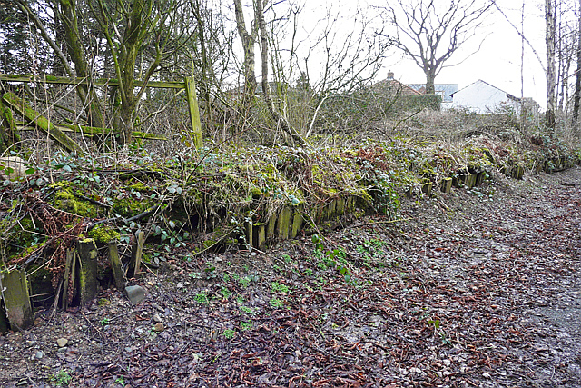
English: Parkhouse Halt - remains of platform This was a station on the Waverley railway line. It was built in 1941 for workers at RAF Kingstown (renamed RAF Carlisle after the war, latterly 14 Maintenance Unit). The railway and halt (with a footbridge over the track) can be seen in an aerial photo of the 14MU complex taken in 1946. Parkhouse Halt was not intended for use by the general public. It closed along with the rest of the Waverley route in 1969. Today a shared-use path occupies the former railway trackbed, running north to south through Kingmoor Nature Reserve. |
| Date | |
| Source | From geograph.org.uk |
| Author | Rose and Trev Clough |
| Permission (Reusing this file) |
Creative Commons Attribution Share-alike license 2.0 |
| Attribution (required by the license) | Rose and Trev Clough / Parkhouse Halt - remains of platform / |
| Camera location | | View this and other nearby images on: OpenStreetMap |
|---|
.jpg¶ms=054.933396_N_-002.960245_E_globe:Earth_type:camera_source:geograph-osgb36(NY38576028)_heading:135.00&language=en)
| Object location | | View this and other nearby images on: OpenStreetMap |
|---|
.jpg¶ms=054.933310_N_-002.960240_E_globe:Earth_class:object_type:object_source:geograph-osgb36(NY38576027)_heading:135.00&language=en)
Licensing

|
This image was taken from the Geograph project collection. See this photograph's page on the Geograph website for the photographer's contact details. The copyright on this image is owned by Rose and Trev Clough and is licensed for reuse under the Creative Commons Attribution-ShareAlike 2.0 license.
|
This file is licensed under the Creative Commons Attribution-Share Alike 2.0 Generic license.
Attribution: Rose and Trev Clough
- You are free:
- to share – to copy, distribute and transmit the work
- to remix – to adapt the work
- Under the following conditions:
- attribution – You must give appropriate credit, provide a link to the license, and indicate if changes were made. You may do so in any reasonable manner, but not in any way that suggests the licensor endorses you or your use.
- share alike – If you remix, transform, or build upon the material, you must distribute your contributions under the same or compatible license as the original.
File history
Click on a date/time to view the file as it appeared at that time.
| Date/Time | Thumbnail | Dimensions | User | Comment | |
|---|---|---|---|---|---|
| current | 20:53, 7 November 2020 | | 640 × 427 (468 KB) | Lamberhurst | Transferred from geograph.co.uk using [https://tools.wmflabs.org/geograph2commons/ geograph2commons] |
File usage
The following pages on the English Wikipedia use this file (pages on other projects are not listed):
.jpg)