
File:Panorama Wardzia.jpg

Size of this preview: 800 × 262 pixels. Other resolutions: 320 × 105 pixels | 640 × 210 pixels | 1,024 × 335 pixels | 1,280 × 419 pixels | 6,082 × 1,992 pixels.
Original file (6,082 × 1,992 pixels, file size: 5.35 MB, MIME type: image/jpeg)
| This is a file from the Wikimedia Commons. Information from its description page there is shown below. Commons is a freely licensed media file repository. You can help. |

|
NOTE: This image is a panorama consisting of multiple frames that were merged or stitched in software. As a result, this image necessarily underwent some form of digital manipulation. These manipulations may include blending, blurring, cloning, and colour and perspective adjustments. As a result of these adjustments, the image content may be slightly different from reality at the points where multiple images were combined. This manipulation is often required due to lens, perspective, and parallax distortions.
|
Summary
| Description |
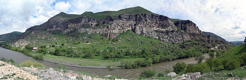
English: Vardzia
Polski: Wardzia
Deutsch: Auf dem Bild sieht man Wardsia, eine Höhlenstadt in Georgien, in der Region Samzche-Dschawachetien. Sie wurde in einem vom Tal von rund 500 Meter aufragende Felswand errichtet. Wardsia enthält heute 750 Räume, ursprünglich waren aber es aber etwa 3.000 Wohnungen für die Einwohner der Stadt. Die Räume sind miteinander durch Tunnel, Treppen, Terrassen und Galerien verbunden. Wardsia ist die größte Höhlenstadt Georgiens. |
| Date | Taken in May 2010 |
| Source | Self-photographed |
| Author | Kotasik |
| Camera location | | View this and other nearby images on: OpenStreetMap |
|---|
Licensing
This file is licensed under the Creative Commons Attribution 3.0 Unported license.
- You are free:
- to share – to copy, distribute and transmit the work
- to remix – to adapt the work
- Under the following conditions:
- attribution – You must give appropriate credit, provide a link to the license, and indicate if changes were made. You may do so in any reasonable manner, but not in any way that suggests the licensor endorses you or your use.
This image has been assessed using the Quality image guidelines and is considered a Quality image.
|
File history
Click on a date/time to view the file as it appeared at that time.
| Date/Time | Thumbnail | Dimensions | User | Comment | |
|---|---|---|---|---|---|
| current | 23:39, 13 May 2011 | 6,082 × 1,992 (5.35 MB) | Pro2 | fixed color, overexpose, crop on the right side | |
| 18:00, 10 July 2010 | 6,104 × 1,992 (2.71 MB) | Kotasik | {{Information |Description={{en|1=Vardzia}} {{pl|1=Wardzia}} |Source={{own}} |Author=Kotasik |Date=05-2010 |Permission={{cc-by-3.0}} |other_versions= }} Category:Vardzia |
File usage
The following pages on the English Wikipedia use this file (pages on other projects are not listed):
Global file usage
The following other wikis use this file:
- Usage on bg.wikipedia.org
- Usage on ca.wikipedia.org
- Usage on de.wikipedia.org
- Usage on el.wikipedia.org
- Usage on fa.wikipedia.org
- Usage on fr.wikipedia.org
- Usage on he.wikipedia.org
- Usage on mt.wikipedia.org
- Usage on ru.wikipedia.org
- Usage on sl.wikipedia.org
- Usage on tr.wikipedia.org
- Usage on uk.wikipedia.org