
File:Palais de justice de Rouen (30812947341).jpg

Size of this preview: 800 × 533 pixels. Other resolutions: 320 × 213 pixels | 640 × 427 pixels | 1,024 × 683 pixels | 1,280 × 853 pixels | 2,560 × 1,707 pixels | 5,520 × 3,680 pixels.
Original file (5,520 × 3,680 pixels, file size: 5.53 MB, MIME type: image/jpeg)
| This is a file from the Wikimedia Commons. Information from its description page there is shown below. Commons is a freely licensed media file repository. You can help. |
.jpg)
Summary
| Description |
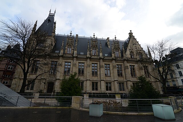
This, the largest civil Gothic edifice in France, was constructed towards the end of the Middle Ages on the remains of the former Jewish quarter of the city, which was destroyed after the expulsion of the Jews in 1306. Construction of the oldest part (the west wing) began in 1499 to house the Exchequer of Normandy (high judicial and financial court).The Exchequer was converted into the Parliament of Normandy in 1515. The building situated to the north, at the back of the courtyard, was added in the 16th century; it is sumptuously decorated and the immense roof is adorned with large attic windows and a balustrade bristling with spires, interconnected by open buttresses. The eastern part of the building (to the right of the courtyard) dates from the 19th century. The visible shell holes in the building's stone walls testify to the violent allied bombing that the city underwent when it was liberated in 1944. The edifice now houses the court house (the assize court in particular) [rouentourisme.com] |
| Date | |
| Source | Palais de justice de Rouen |
| Author | Jorge Láscar from Melbourne, Australia |
| Camera location | | View this and other nearby images on: OpenStreetMap |
|---|
.jpg¶ms=049.442449_N_0001.089497_E_globe:Earth_type:camera_source:Flickr_&language=en)
Licensing
This file is licensed under the Creative Commons Attribution 2.0 Generic license.
- You are free:
- to share – to copy, distribute and transmit the work
- to remix – to adapt the work
- Under the following conditions:
- attribution – You must give appropriate credit, provide a link to the license, and indicate if changes were made. You may do so in any reasonable manner, but not in any way that suggests the licensor endorses you or your use.
| This image was originally posted to Flickr by Jorge Lascar at https://flickr.com/photos/8721758@N06/30812947341 (archive). It was reviewed on 31 January 2018 by FlickreviewR 2 and was confirmed to be licensed under the terms of the cc-by-2.0. |
File history
Click on a date/time to view the file as it appeared at that time.
| Date/Time | Thumbnail | Dimensions | User | Comment | |
|---|---|---|---|---|---|
| current | 15:26, 31 January 2018 | | 5,520 × 3,680 (5.53 MB) | Thesupermat2 | Transferred from Flickr via Flickr2Commons |
File usage
The following pages on the English Wikipedia use this file (pages on other projects are not listed):
Global file usage
The following other wikis use this file:
- Usage on bn.wikipedia.org
- Usage on fr.wikipedia.org
.jpg)