
File:PIA16231-MarsCuriosityRover-Tray-20121015.jpg

Original file (1,024 × 1,024 pixels, file size: 158 KB, MIME type: image/jpeg)
| This is a file from the Wikimedia Commons. Information from its description page there is shown below. Commons is a freely licensed media file repository. You can help. |
Summary
| Description |
English: 10.18.2012
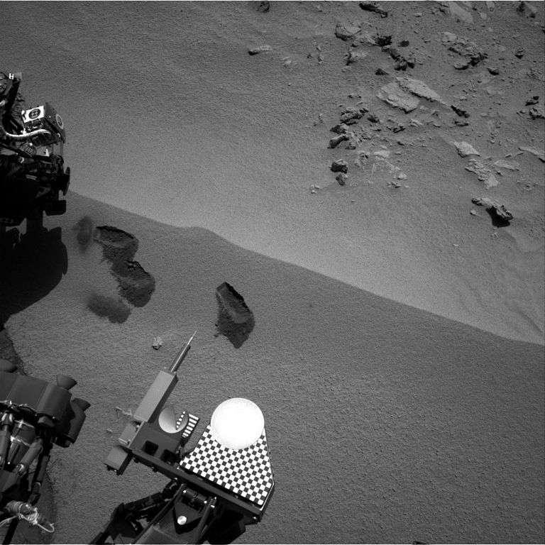
Curiosity's First Three Bites Into Martian Ground Three bite marks left in the Martian ground by the scoop on the robotic arm of NASA's Mars rover Curiosity are visible in this image taken by the rover's right Navigation Camera during the mission's 69th Martian day, or sol (Oct. 15, 2012). The third scoopful, collected on that sol, left the bite or pit farthest to the right. Each of the three bites is about 2 inches (5 centimeters) wide. Of the two bites to the left, the lower one is where Curiosity collected its first scoopful of Martian material, on Sol 61 (Oct. 7, 2012). The upper one is the site of the second scooping, on Sol 66 (Oct. 12, 2012). The location for all of these scoops, and two more planned, is a ripple of windblown dust and sand at a location called "Rocknest." The bright circular part of the rover near the bottom center of this image is the observation tray, which is 3 inches (7.8 centimeters) in diameter.Polski: Trzy ślady czerpaka CHIMRA, pozostawione w marsjańskim gruncie. CHIMRA jest jednym z pięciu urządzeń umieszczonych na rewolwerowej wieżyczce wysięgnika łazika Curiosity. Zdjęcie to, wykonała prawa kamera nawigacyjna, podczas 69 marsjańskiego dnia misji łazika na Marsie, albo Sol 69 (15 października 2012). Trzeci dołek, lub ślad ugryzienia czerpaka CHIMRA, zebrany w tym samym marsjańskim dniu, jest wysunięty najdalej na prawo. Każdy z trzech śladów ma 5 cm szerokości Z dwóch dołków, które pozostały po pobieraniu próbek przez czerpak CHIMRA, niższy jest tym, gdzie pobrano próbkę po raz pierwszy. Wydarzenie miało miejsce 61 marsjańskiego dnia misji łazika na Marsie (07 października 2012). Górny dołek pozostał po drugim nabieraniu w 66 marsjańskim dniu misji (12 października 2012). Usytuowanie tych wszystkich dołków i kolejnych dwóch planowanych, jest związane z łachą kurzu i piasku, w miejscu zwanym "Rocknest".Jasny okrągły krążek, część łazika w pobliżu centrum, w dolnej części tego zdjęcia, to tacka obserwacyjna przetworzonych próbek, która ma 7,8 cm średnicy. Image Credit: NASA/JPL-Caltech |
| Date | |
| Source | http://photojournal.jpl.nasa.gov/jpeg/PIA16231.jpg |
| Author | NASA/JPL-Caltech |
| Other versions | http://photojournal.jpl.nasa.gov/catalog/PIA16231 |
Licensing
| This file is in the public domain in the United States because it was solely created by NASA. NASA copyright policy states that "NASA material is not protected by copyright unless noted". (See Template:PD-USGov, NASA copyright policy page or JPL Image Use Policy.) | ||
 |
Warnings:
|
File history
Click on a date/time to view the file as it appeared at that time.
| Date/Time | Thumbnail | Dimensions | User | Comment | |
|---|---|---|---|---|---|
| current | 01:29, 19 October 2012 | | 1,024 × 1,024 (158 KB) | Drbogdan | User created page with UploadWizard |
File usage
Global file usage
The following other wikis use this file:
- Usage on es.wikipedia.org
- Usage on pl.wikipedia.org
- Usage on zh.wikipedia.org