
File:Ostseetiefen.png

Size of this preview: 503 × 600 pixels. Other resolutions: 201 × 240 pixels | 402 × 480 pixels | 826 × 985 pixels.
Original file (826 × 985 pixels, file size: 94 KB, MIME type: image/png)
| This is a file from the Wikimedia Commons. Information from its description page there is shown below. Commons is a freely licensed media file repository. You can help. |
Summary
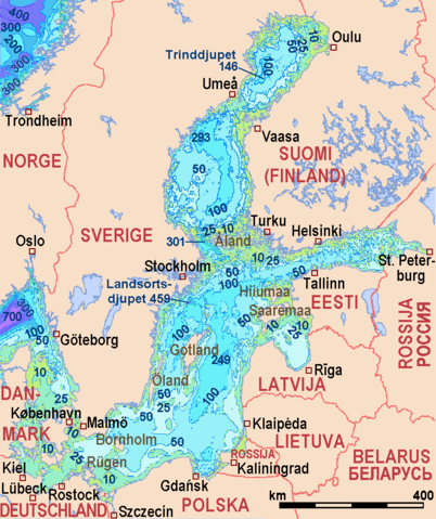
| Description | Depths of Baltic Sea and Skagerak |
| Date | |
| Source | Coastlines: File:Baltic_Sea_location_map.svg by NordNordWest |
| Author | Own work |
Sources of information
- Swedish Meteorological and Hydrological Institute: The Baltic Sea, Kattegat and Skagerak – sea areas and drainage basins archive copy at the Wayback Machine
- Baltic Nest Institute
- Global Ocean Associates: Atlas of Oceanic Internal Solkitary Waves (February 2004)
Licensing
I, the copyright holder of this work, hereby publish it under the following licenses:

|
Permission is granted to copy, distribute and/or modify this document under the terms of the GNU Free Documentation License, Version 1.2 or any later version published by the Free Software Foundation; with no Invariant Sections, no Front-Cover Texts, and no Back-Cover Texts. A copy of the license is included in the section entitled GNU Free Documentation License. |
This file is licensed under the Creative Commons Attribution-Share Alike 3.0 Unported license.
- You are free:
- to share – to copy, distribute and transmit the work
- to remix – to adapt the work
- Under the following conditions:
- attribution – You must give appropriate credit, provide a link to the license, and indicate if changes were made. You may do so in any reasonable manner, but not in any way that suggests the licensor endorses you or your use.
- share alike – If you remix, transform, or build upon the material, you must distribute your contributions under the same or compatible license as the original.
You may select the license of your choice.
File history
Click on a date/time to view the file as it appeared at that time.
| Date/Time | Thumbnail | Dimensions | User | Comment | |
|---|---|---|---|---|---|
| current | 11:59, 18 June 2014 | | 826 × 985 (94 KB) | Kopiersperre | optipng |
| 12:15, 13 May 2014 |  | 826 × 985 (99 KB) | Ulamm | colourscale optimized | |
| 21:56, 4 May 2014 |  | 826 × 985 (185 KB) | Ulamm | deepest site of Bottenviken | |
| 21:07, 4 May 2014 |  | 826 × 985 (184 KB) | Ulamm | typo | |
| 19:01, 17 April 2014 |  | 826 × 985 (184 KB) | Ulamm | more detailed bathymetry from [http://topex.ucsd.edu/WWW_html/srtm30_plus.html SRTM30_PLUS]<br/> maximum depths from [http://www.smhi.se/sgn0102/n0205/havsomr/havsomr_plansch.pdf Swedish Meteorological and Hydrological Institute: The Baltic Sea, Katteg... | |
| 12:04, 14 April 2014 |  | 826 × 985 (117 KB) | Ulamm | depths of Norwegian Sea, names of the states and some isöands | |
| 15:16, 13 April 2014 |  | 826 × 985 (107 KB) | Ulamm | Landsortsdjupet | |
| 14:30, 13 April 2014 |  | 826 × 985 (106 KB) | Ulamm | + scale | |
| 14:14, 13 April 2014 |  | 826 × 985 (106 KB) | Ulamm | Text had not yet been stored- | |
| 14:12, 13 April 2014 |  | 826 × 985 (99 KB) | Ulamm | {{Information |Description=Depths of Baltic Sea and Skagerak |Source= Coastlines: 869px-Baltic_Sea_location_map.svg.png |Date=2014-04-13 |Author={{own}} |Permission= |other_versions= }} ==Sources of information== *[http://nest.su.se/baltic96/depth... |
File usage
The following pages on the English Wikipedia use this file (pages on other projects are not listed):
Global file usage
The following other wikis use this file:
- Usage on ba.wikipedia.org
- Usage on be.wikipedia.org
- Usage on cs.wikipedia.org
- Usage on da.wikipedia.org
- Usage on de.wikipedia.org
- Usage on et.wikipedia.org
- Usage on fr.wikipedia.org
- Usage on hr.wikipedia.org
- Usage on it.wikipedia.org
- Usage on ja.wikipedia.org
- Usage on lt.wikipedia.org
- Usage on nl.wikipedia.org
- Usage on pl.wikipedia.org
- Usage on ru.wikipedia.org
- Usage on sv.wikipedia.org
- Usage on www.wikidata.org
- Usage on zh.wikipedia.org