
File:Osmanu-vilajeti-haleba.svg

Size of this PNG preview of this SVG file: 600 × 400 pixels. Other resolutions: 320 × 213 pixels | 640 × 427 pixels | 1,024 × 683 pixels | 1,280 × 853 pixels | 2,560 × 1,707 pixels.
Original file (SVG file, nominally 600 × 400 pixels, file size: 228 KB)
| This is a file from the Wikimedia Commons. Information from its description page there is shown below. Commons is a freely licensed media file repository. You can help. |
Summary
Kopsavilkums
| Description |
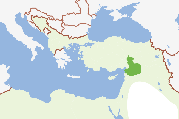
English: Location of Haleb Vilayeti in the Ottoman Empire (1900)
Latviešu: Halepas vilājeta atrašanās vieta Osmaņu impērijā (1900) |
| Date | |
| Source | Own work |
| Author | Juris Tiltins |
| SVG development | This map was created with Adobe Illustrator. |
Licensing
| I, the copyright holder of this work, release this work into the public domain. This applies worldwide. In some countries this may not be legally possible; if so: I grant anyone the right to use this work for any purpose, without any conditions, unless such conditions are required by law. |
File history
Click on a date/time to view the file as it appeared at that time.
| Date/Time | Thumbnail | Dimensions | User | Comment | |
|---|---|---|---|---|---|
| current | 16:11, 28 June 2008 | | 600 × 400 (228 KB) | Juristiltins | {{Information |Description={{en|1=Location of Haleb Vilayeti in the Ottoman Empire (1900)}} {{lv|1=Halepas vilājeta atrašanās vieta Osmaņu impērijā (1900)}} |Source=Own work |Author=Juris Tiltins |Date=28 June 2008 |Permission=See below |other_versi |
File usage
The following pages on the English Wikipedia use this file (pages on other projects are not listed):
Global file usage
The following other wikis use this file:
- Usage on azb.wikipedia.org
- Usage on it.wikipedia.org
- Usage on lv.wikipedia.org
- Usage on ro.wikipedia.org
- Usage on tr.wikipedia.org