
File:Olin Township.jpg

Size of this preview: 593 × 599 pixels. Other resolutions: 238 × 240 pixels | 475 × 480 pixels | 877 × 886 pixels.
Original file (877 × 886 pixels, file size: 222 KB, MIME type: image/jpeg)
| This is a file from the Wikimedia Commons. Information from its description page there is shown below. Commons is a freely licensed media file repository. You can help. |
Summary
| Description |
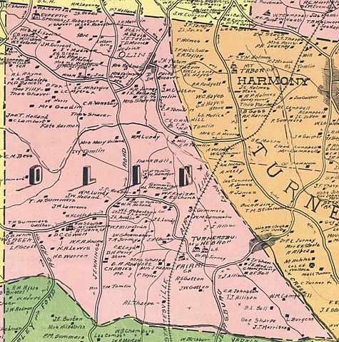
English: created from original map from 1917 by N.R. Kinney; Printed in color, mounted on linen. Townships designated by color. Map shows school districts, mills, churches, retail stores, rural mail routes, African American churches, townships, landowners, schools, African American schools, dairies, tenants, and railroads including the Southern Railway and the "Proposed Statesville Air Line Railway." Townships shown include New Hope, Union Grove, Eagle Mills, Sharpsburg, Olin, Turnersburg, Concord, Bethany, Cool Springs, Shiloh, Statesville, Chambersburg, Fallstown, Barringers, Davidson, and Coddle Creek. |
| Date | |
| Source | https://dc.lib.unc.edu/cdm/singleitem/collection/ncmaps/id/413/rec/16 |
| Author | Kinney, N.R. |
Licensing
|
This work is in the public domain in its country of origin and other countries and areas where the copyright term is the author's life plus 70 years or fewer. This work is in the public domain in the United States because it was published (or registered with the U.S. Copyright Office) before January 1, 1929. | |
| This file has been identified as being free of known restrictions under copyright law, including all related and neighboring rights. | |
File history
Click on a date/time to view the file as it appeared at that time.
| Date/Time | Thumbnail | Dimensions | User | Comment | |
|---|---|---|---|---|---|
| current | 16:10, 26 February 2019 | | 877 × 886 (222 KB) | G. Moore | User created page with UploadWizard |
File usage
The following pages on the English Wikipedia use this file (pages on other projects are not listed):