
File:Old Lavant Station. - geograph.org.uk - 1136123.jpg
No higher resolution available.
Old_Lavant_Station._-_geograph.org.uk_-_1136123.jpg (640 × 408 pixels, file size: 61 KB, MIME type: image/jpeg)
| This is a file from the Wikimedia Commons. Information from its description page there is shown below. Commons is a freely licensed media file repository. You can help. |
Summary
| Description |
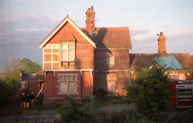
English: Old Lavant Station Just off the A286, I discovered this old railway station, with the fire brigade in attendance. It was an evening in 1988. The Station building was saved and converted to residential use and remains so to this day, however extensive house building in the intervening 20 years in the surrounding area, has made it difficult to locate. |
| Date | |
| Source | From geograph.org.uk; transferred by User:oxyman using geograph_org2commons. |
| Author | Clive Warneford |
| Permission (Reusing this file) |
Creative Commons Attribution Share-alike license 2.0 |
| Camera location | | View this and other nearby images on: OpenStreetMap |
|---|
| Object location | | View this and other nearby images on: OpenStreetMap |
|---|
_region:GB-ENG_heading:67.00&language=en)
Licensing

|
This image was taken from the Geograph project collection. See this photograph's page on the Geograph website for the photographer's contact details. The copyright on this image is owned by Clive Warneford and is licensed for reuse under the Creative Commons Attribution-ShareAlike 2.0 license.
|
This file is licensed under the Creative Commons Attribution-Share Alike 2.0 Generic license.
Attribution: Clive Warneford
- You are free:
- to share – to copy, distribute and transmit the work
- to remix – to adapt the work
- Under the following conditions:
- attribution – You must give appropriate credit, provide a link to the license, and indicate if changes were made. You may do so in any reasonable manner, but not in any way that suggests the licensor endorses you or your use.
- share alike – If you remix, transform, or build upon the material, you must distribute your contributions under the same or compatible license as the original.
File history
Click on a date/time to view the file as it appeared at that time.
| Date/Time | Thumbnail | Dimensions | User | Comment | |
|---|---|---|---|---|---|
| current | 05:08, 23 April 2009 | | 640 × 408 (61 KB) | File Upload Bot (Magnus Manske) | == Summary == {{Information |Description=Old Lavant Station. |Source=From [http://www.geograph.org.uk/photo/1136123 geograph.org.uk]; transferd by User:oxyman using [http://toolserver.org/~magnus/geograph_org2commons.php geograph_org2commons]. |Date= |
File usage
The following pages on the English Wikipedia use this file (pages on other projects are not listed):
Global file usage
The following other wikis use this file:
- Usage on arz.wikipedia.org
- Usage on www.wikidata.org