
File:Okterritory.png

Size of this preview: 800 × 477 pixels. Other resolutions: 320 × 191 pixels | 640 × 382 pixels | 1,024 × 611 pixels | 1,280 × 763 pixels | 2,515 × 1,500 pixels.
Original file (2,515 × 1,500 pixels, file size: 534 KB, MIME type: image/png)
| This is a file from the Wikimedia Commons. Information from its description page there is shown below. Commons is a freely licensed media file repository. You can help. |

|
This locator map image could be re-created using vector graphics as an SVG file. This has several advantages; see Commons:Media for cleanup for more information. If an SVG form of this image is available, please upload it and afterwards replace this template with
{{vector version available|new image name}}.
It is recommended to name the SVG file “Okterritory.svg”—then the template Vector version available (or Vva) does not need the new image name parameter. |
Summary
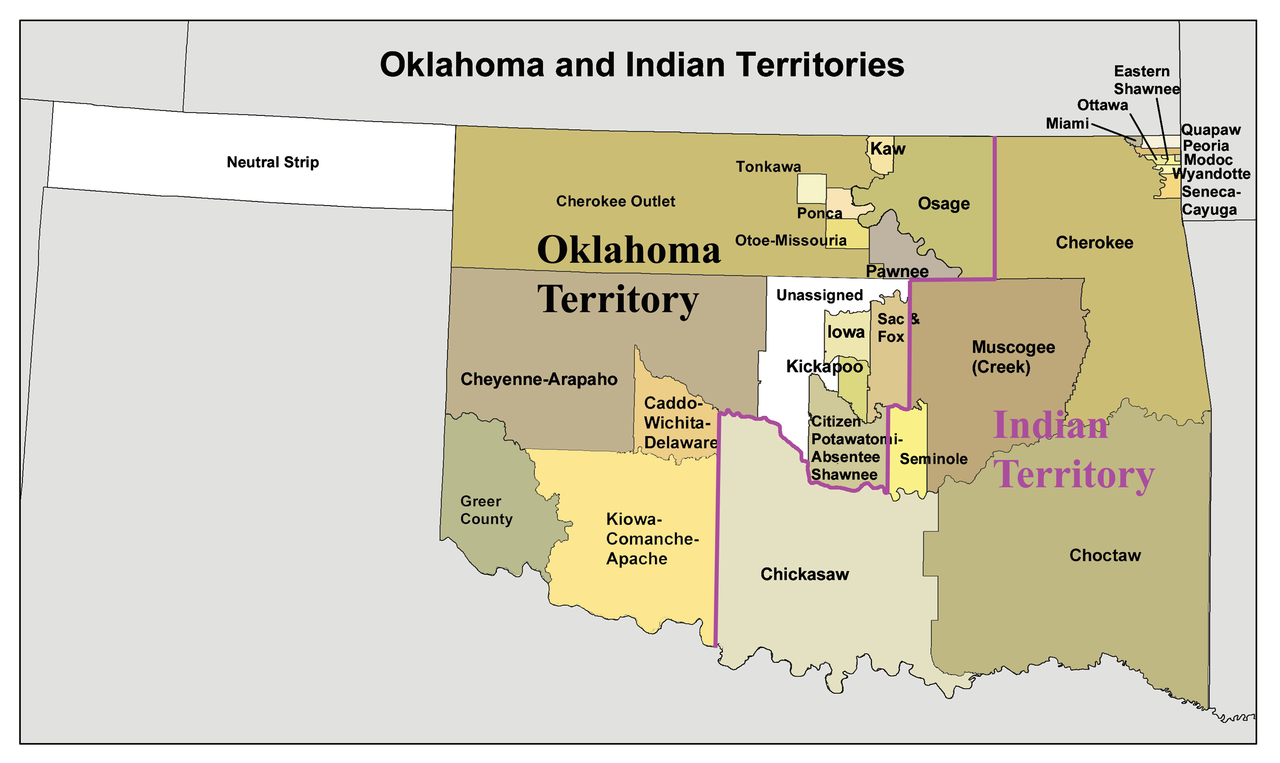
English: A map of the Oklahoma Territory and the reduced Indian Territory circa 1890's.
- In present day Oklahoma.
- Credits
- I made this using Census Bureau data and this 1892 map as a reference.
Licensing
I, the copyright holder of this work, hereby publish it under the following license:
This file is licensed under the Creative Commons Attribution-Share Alike 3.0 Unported license.
- You are free:
- to share – to copy, distribute and transmit the work
- to remix – to adapt the work
- Under the following conditions:
- attribution – You must give appropriate credit, provide a link to the license, and indicate if changes were made. You may do so in any reasonable manner, but not in any way that suggests the licensor endorses you or your use.
- share alike – If you remix, transform, or build upon the material, you must distribute your contributions under the same or compatible license as the original.
File history
Click on a date/time to view the file as it appeared at that time.
| Date/Time | Thumbnail | Dimensions | User | Comment | |
|---|---|---|---|---|---|
| current | 16:34, 20 January 2010 | | 2,515 × 1,500 (534 KB) | Kmusser | spelling correction |
| 15:10, 20 January 2010 |  | 2,551 × 1,500 (557 KB) | Kmusser | increased resolution | |
| 18:02, 31 July 2006 |  | 600 × 358 (33 KB) | Kmusser | == Summary == This is a map of Oklahoma and Indian Territory circa 1890's that I made using and Census Bureau data and [http://hdl.loc.gov/loc.gmd/g4021e.ct000224 this |
File usage
The following pages on the English Wikipedia use this file (pages on other projects are not listed):
- Atoka County, Choctaw Nation
- Cherokee Commission
- Cherokee Nation (1794–1907)
- Commerce, Oklahoma
- Historical regions of the United States
- History of Oklahoma
- Northwestern Oklahoma
- Oklahoma Organic Act
- Oklahoma Territorial Legislature
- Oklahoma panhandle
- Osage Nation
- Socialist Party of Oklahoma
- State of Sequoyah
- Stringtown, Oklahoma
- Treaty of the Wabash
- United States v. Ramsey (1926)
- User:Joelton Ivson/Gather lists/24319 – Indígenas América do Norte
- User:Kmusser/Images
- Portal:Oklahoma
Global file usage
The following other wikis use this file:
- Usage on af.wikipedia.org
- Usage on ar.wikipedia.org
- Usage on arz.wikipedia.org
- Usage on bcl.wikipedia.org
- Usage on bn.wikipedia.org
- Usage on ca.wikipedia.org
- Osages
- Chickasaw (grup humà)
- Choctaws
- Wichita (poble)
- Tonkawes
- Caddos
- Comtat de Cimarron
- Comtat de Beaver (Oklahoma)
- Oklahoma Panhandle
- Cinc tribus civilitzades
- Apatxe kiowa
- Territori Indi
- Nació Chickasaw
- Plantilla:Territori Indi
- Nació Choctaw d'Oklahoma
- Districte Apukshunnubbee
- Districte Moshulatubbee
- Districte Pushmataha
- Nació Muscogee
- Estat de Sequoyah
- Nació Seminola d'Oklahoma
- Indian Intercourse Act
- Llei Orgànica d'Oklahoma
- Usage on chr.wikipedia.org
- Usage on chy.wikipedia.org
- Usage on cy.wikipedia.org
- Usage on de.wikipedia.org
View more global usage of this file.