
File:Okhotsk Plate map en.png
Size of this preview: 443 × 600 pixels. Other resolutions: 177 × 240 pixels | 628 × 850 pixels.
Original file (628 × 850 pixels, file size: 40 KB, MIME type: image/png)
| This is a file from the Wikimedia Commons. Information from its description page there is shown below. Commons is a freely licensed media file repository. You can help. |
| Description |
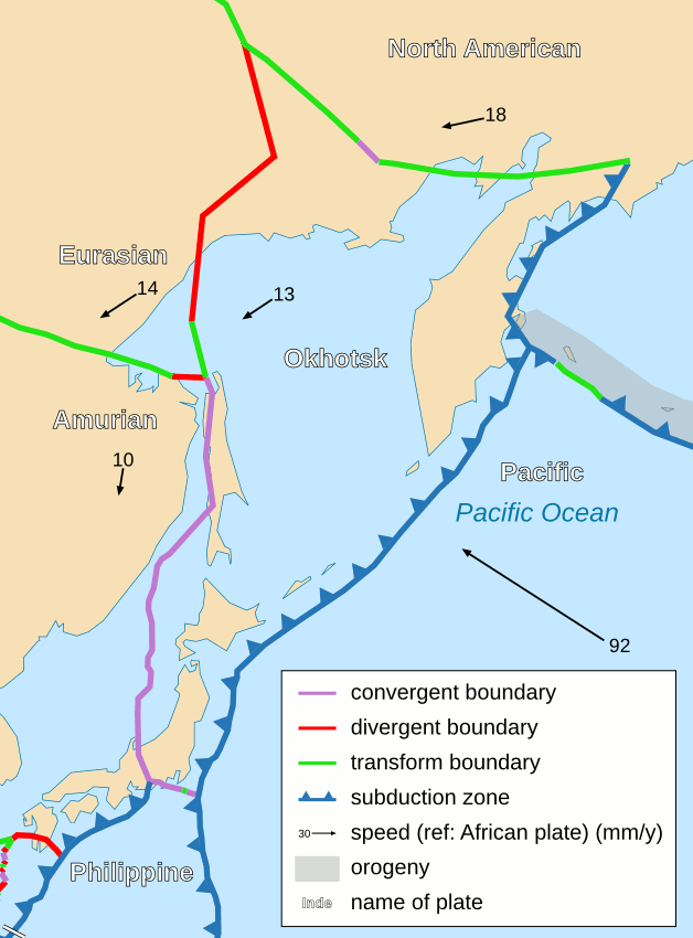
English: Area around Okhotsk plate. |
| Date | (UTC) |
| Source | |
| Author |
|
| Other versions |
Derivative works of this file: |
| This is a retouched picture, which means that it has been digitally altered from its original version. Modifications: Same as File:Tectonic_plates_boundaries_detailed-fr.svg except in English. The original can be viewed here: Tectonic plates boundaries detailed-fr.svg:
|
I, the copyright holder of this work, hereby publish it under the following license:
This file is licensed under the Creative Commons Attribution-Share Alike 2.5 Generic license.
- You are free:
- to share – to copy, distribute and transmit the work
- to remix – to adapt the work
- Under the following conditions:
- attribution – You must give appropriate credit, provide a link to the license, and indicate if changes were made. You may do so in any reasonable manner, but not in any way that suggests the licensor endorses you or your use.
- share alike – If you remix, transform, or build upon the material, you must distribute your contributions under the same or compatible license as the original.
Original upload log
This image is a derivative work of the following images:
- File:Tectonic_plates_boundaries_detailed-fr.svg licensed with Cc-by-sa-2.5, Cc-by-sa-2.5/en
- 2008-08-31T23:27:25Z Sting 4896x2471 (790111 Bytes) A bit smaller to export in PNG
- 2008-06-02T20:24:47Z Sting 5000x2525 (850547 Bytes) South NZ subduction zone correction
- 2006-10-25T14:23:54Z Sting 5000x2525 (853764 Bytes) Forgotten arrow
- 2006-10-25T13:56:52Z Sting 5000x2525 (854406 Bytes) Lighter version
- 2006-10-25T00:43:14Z Sting 5000x2525 (936674 Bytes) {{Information| |Description=Detailed world map in French showing the tectonic plates with their movement vectors |Source= '''Background map (modified) :''' [[:Image:Tectonic plates (empty).svg]] created by [[User:Ævar Arnfj�
Uploaded with derivativeFX
File history
Click on a date/time to view the file as it appeared at that time.
| Date/Time | Thumbnail | Dimensions | User | Comment | |
|---|---|---|---|---|---|
| current | 22:06, 1 January 2009 | | 628 × 850 (40 KB) | Psbsub | {{Information |Description={{en|Area around Okhotsk plate.}} |Source=*File:Tectonic_plates_boundaries_detailed-fr.svg |Date=2009-01-01 22:05 (UTC) |Author=*derivative work: ~~~ *File:Tectonic_plates_boundaries_detailed-fr.svg: Eric Gaba ([[Use |
File usage
The following pages on the English Wikipedia use this file (pages on other projects are not listed):
Global file usage
The following other wikis use this file:
- Usage on az.wikipedia.org
- Usage on de.wikipedia.org
- Usage on eu.wikipedia.org
- Usage on pl.wikipedia.org
- Usage on ru.wikipedia.org
- Usage on sh.wikipedia.org
- Usage on vi.wikipedia.org