
File:OdrysianKingdom.jpg

Size of this preview: 800 × 512 pixels. Other resolutions: 320 × 205 pixels | 640 × 409 pixels | 1,102 × 705 pixels.
Original file (1,102 × 705 pixels, file size: 691 KB, MIME type: image/jpeg)
| This is a file from the Wikimedia Commons. Information from its description page there is shown below. Commons is a freely licensed media file repository. You can help. |

|
File:Odrysian kingdom of Thrace & Environs (English).svg is a vector version of this file. It should be used in place of this JPG file when not inferior.
File:OdrysianKingdom.jpg → File:Odrysian kingdom of Thrace & Environs (English).svg
For more information, see Help:SVG. |
.svg) |
Summary
| Description |
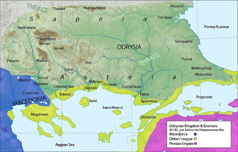
English: Map of the Odrysian kingdom & Environs,431 BC,The location of the Thracian tribes are approximate (see page 108 Fig. 4.2 from the The Odrysian Kingdom of Thrace cited below)
Own work,data from
|
| Date | |
| Source | Own work |
| Author | Megistias |
| Other versions |
  |
Licensing
| I, the copyright holder of this work, release this work into the public domain. This applies worldwide. In some countries this may not be legally possible; if so: I grant anyone the right to use this work for any purpose, without any conditions, unless such conditions are required by law. |
File history
Click on a date/time to view the file as it appeared at that time.
| Date/Time | Thumbnail | Dimensions | User | Comment | |
|---|---|---|---|---|---|
| current | 08:03, 4 June 2017 | | 1,102 × 705 (691 KB) | Mélomène | More contrast for the Odrysian kingdom |
| 09:57, 17 October 2015 |  | 1,102 × 705 (691 KB) | Spiridon Ion Cepleanu | Little changes : antic shoreline, latin orthography (names of the tribes) | |
| 16:28, 7 December 2014 |  | 1,102 × 705 (690 KB) | Spiridon Ion Cepleanu | Sapeia, Asteia | |
| 20:42, 16 February 2010 |  | 1,102 × 705 (670 KB) | Megistias | == {{int:filedesc}} == {{Information |Description={{en|1=Map of the Odrysian kingdom & Environs,431 BC, Own work,data from *The Odrysian Kingdom of Thrace: Orpheus Unmasked (Oxford Monographs on Classical Archaeology) by Z. H. Archibald,1998,ISBN-10-0198 |
File usage
The following pages on the English Wikipedia use this file (pages on other projects are not listed):
- Apsinthii
- Asti (Thracian tribe)
- Bessi
- Bisaltae
- Bistones
- Cicones
- Crestonia
- Dentheletae
- Dii
- Dolonci
- Edoni
- List of ancient Daco-Thracian peoples and tribes
- List of kings of Thrace and Dacia
- Melanditi
- Melinophagi
- Nipsai
- Paiti
- Sapaeans
- Satrae
- Scyrmiadae
- Sintians
- Sitalces
- Thrace
- Thracian warfare
- Thyni
- Tilataei
- Tranipsi
- User:Falcaorib
Global file usage
The following other wikis use this file:
- Usage on ar.wikipedia.org
- Usage on arz.wikipedia.org
- Usage on be.wikipedia.org
- Usage on bg.wikipedia.org
- Usage on ca.wikipedia.org
- Usage on da.wikipedia.org
- Usage on de.wikipedia.org
- Usage on el.wikipedia.org
- Usage on fa.wikipedia.org
- Usage on fr.wikipedia.org
- Usage on fr.wiktionary.org
- Usage on id.wikipedia.org
- Usage on it.wikipedia.org
View more global usage of this file.