
File:Oceans and seas boundaries map-en.svg

Size of this PNG preview of this SVG file: 800 × 406 pixels. Other resolutions: 320 × 162 pixels | 640 × 325 pixels | 1,024 × 519 pixels | 1,280 × 649 pixels | 2,560 × 1,299 pixels | 4,000 × 2,029 pixels.
Original file (SVG file, nominally 4,000 × 2,029 pixels, file size: 1.39 MB)
| This is a file from the Wikimedia Commons. Information from its description page there is shown below. Commons is a freely licensed media file repository. You can help. |
Summary
| Description |
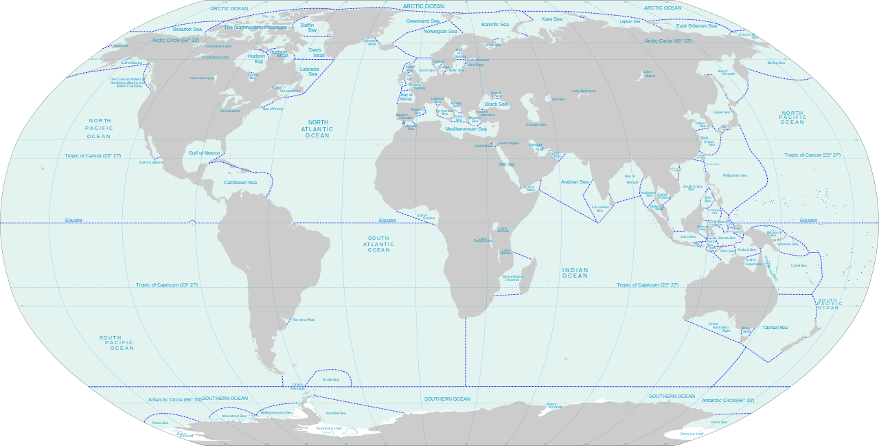
English: World map of oceans and seas : English version |
| Date | (UTC) |
| Source |
Own work using:
|
| Author | |
| Other versions | Turkish version, French version |
| This is a retouched picture, which means that it has been digitally altered from its original version. Modifications: Translated remaining French labels, fixed some English labels, added missing sea and lake names, added missing lake, refactored text styling of some labels to match the rest, fixed rainbow of colors assigned to random islands, added missing Malta and Bermuda islands. The original can be viewed here: Oceans and seas boundaries map-en.svg:
|
I, the copyright holder of this work, hereby publish it under the following licenses:
This file is licensed under the Creative Commons Attribution-Share Alike 3.0 Unported, 2.5 Generic, 2.0 Generic and 1.0 Generic license.
- You are free:
- to share – to copy, distribute and transmit the work
- to remix – to adapt the work
- Under the following conditions:
- attribution – You must give appropriate credit, provide a link to the license, and indicate if changes were made. You may do so in any reasonable manner, but not in any way that suggests the licensor endorses you or your use.
- share alike – If you remix, transform, or build upon the material, you must distribute your contributions under the same or compatible license as the original.

|
Permission is granted to copy, distribute and/or modify this document under the terms of the GNU Free Documentation License, Version 1.2 or any later version published by the Free Software Foundation; with no Invariant Sections, no Front-Cover Texts, and no Back-Cover Texts. A copy of the license is included in the section entitled GNU Free Documentation License. |
You may select the license of your choice.
Original upload log
This image is a derivative work of the following images:
- File:Oceans and seas boundaries map-fr.svg licensed with Cc-by-sa-3.0,2.5,2.0,1.0, GFDL
- 2021-04-05T01:32:50Z Dziban303 2753x1538 (1276318 Bytes) == {{int:filedesc}} == {{Information |Description={{en|World map of oceans and seas : English version}} |Source={{Derived from|Oceans and seas boundaries map-en.svg|display=50}} |Date=2021-04-05 01:09 (UTC) |Author=* [[:File:
- 2021-04-04T21:12:48Z Dziban303 2753x1538 (1268270 Bytes) == {{int:filedesc}} == {{Information |Description=English: World map of oceans and seas : English version|Source={{Derived from|Oceans and seas boundaries map-en.svg|display=50}} |Date=2021-04-04 21:10 (UTC) |Author=* [[:File:
- 2011-02-13T11:57:29Z Jugger90 2753x1538 (1263323 Bytes) {{Information |Description={{en|World map of oceans and seas : french version}} {{fr|Carte des océans et des mers du monde : version vide}} |Source=*[[:File:Oceans_and_seas_boundaries_map-fr.svg|]] |Date=2011-02-13 11:56 (UT
Uploaded with derivativeFX
File history
Click on a date/time to view the file as it appeared at that time.
| Date/Time | Thumbnail | Dimensions | User | Comment | |
|---|---|---|---|---|---|
| current | 14:11, 11 June 2021 | | 4,000 × 2,029 (1.39 MB) | Ibrahim Muizzuddin | Edit toponymy, resize |
| 13:35, 11 June 2021 |  | 2,753 × 1,396 (1.22 MB) | Ibrahim Muizzuddin | Fit image | |
| 02:13, 5 April 2021 |  | 2,753 × 1,538 (1.22 MB) | Dziban303 | == {{int:filedesc}} == {{Information |Description={{en|World map of oceans and seas — English version}} |Source={{Derived from|Oceans and seas boundaries map-en.svg|display=50}} |Date=2021-04-05 02:11 (UTC) |Author=* File:Oceans and seas boundaries map-en.svg: *Oceans_and_seas_boundaries_map-fr.svg: Pinpin * derivative work: Jugger90 ([[User talk:Jugger90|<span cla... | |
| 01:32, 5 April 2021 |  | 2,753 × 1,538 (1.22 MB) | Dziban303 | == {{int:filedesc}} == {{Information |Description={{en|World map of oceans and seas : English version}} |Source={{Derived from|Oceans and seas boundaries map-en.svg|display=50}} |Date=2021-04-05 01:09 (UTC) |Author=* File:Oceans and seas boundaries map-en.svg: *Oceans_and_seas_boundaries_map-fr.svg: Pinpin *derivative work: Jugger90 ([[User talk:Jugger90|<span clas... | |
| 21:12, 4 April 2021 |  | 2,753 × 1,538 (1.21 MB) | Dziban303 | == {{int:filedesc}} == {{Information |Description={{en|World map of oceans and seas : English version}} |Source={{Derived from|Oceans and seas boundaries map-en.svg|display=50}} |Date=2021-04-04 21:10 (UTC) |Author=* File:Oceans and seas boundaries map-en.svg: *Oceans_and_seas_boundaries_map-fr.svg: Pinpin *derivative work: Jugger90 ([[User talk:Jugger90|<span clas... | |
| 11:57, 13 February 2011 |  | 2,753 × 1,538 (1.2 MB) | Jugger90 | {{Information |Description={{en|World map of oceans and seas : french version}} {{fr|Carte des océans et des mers du monde : version vide}} |Source=*File:Oceans_and_seas_boundaries_map-fr.svg |Date=2011-02-13 11:56 (UTC) |Author=*[[:File:Oceans_and |
File usage
The following pages on the English Wikipedia use this file (pages on other projects are not listed):
Global file usage
The following other wikis use this file:
- Usage on ar.wikipedia.org
- Usage on ast.wikipedia.org
- Usage on bh.wikipedia.org
- Usage on blk.wikipedia.org
- Usage on bs.wikipedia.org
- Usage on ceb.wikipedia.org
- Usage on da.wikipedia.org
- Usage on de.wikipedia.org
- Usage on el.wikipedia.org
- Usage on eo.wikipedia.org
- Usage on es.wikipedia.org
- Usage on eu.wikipedia.org
- Usage on fa.wikipedia.org
- Usage on fi.wikipedia.org
- Usage on id.wikipedia.org
- Usage on ilo.wikipedia.org
- Usage on it.wikipedia.org
- Usage on ka.wikipedia.org
- Usage on kn.wikipedia.org
- Usage on mk.wikipedia.org
- Usage on mn.wikipedia.org
- Usage on mr.wikipedia.org
- Usage on ms.wikipedia.org
- Usage on ru.wikipedia.org
- Usage on sh.wikipedia.org
- Usage on sl.wikipedia.org
- Usage on sn.wikipedia.org
- Usage on sv.wikipedia.org
- Usage on th.wikipedia.org
- Usage on ur.wikipedia.org
- Usage on vi.wikipedia.org
- Usage on zh.wikipedia.org