
File:Oceania UN Geoscheme - Map of Micronesia.svg

Size of this PNG preview of this SVG file: 800 × 462 pixels. Other resolutions: 320 × 185 pixels | 640 × 370 pixels | 1,024 × 592 pixels | 1,280 × 740 pixels | 2,560 × 1,479 pixels | 900 × 520 pixels.
Original file (SVG file, nominally 900 × 520 pixels, file size: 519 KB)
| This is a file from the Wikimedia Commons. Information from its description page there is shown below. Commons is a freely licensed media file repository. You can help. |
Summary
This W3C-unspecified vector image was created with Adobe Illustrator.
| Description |
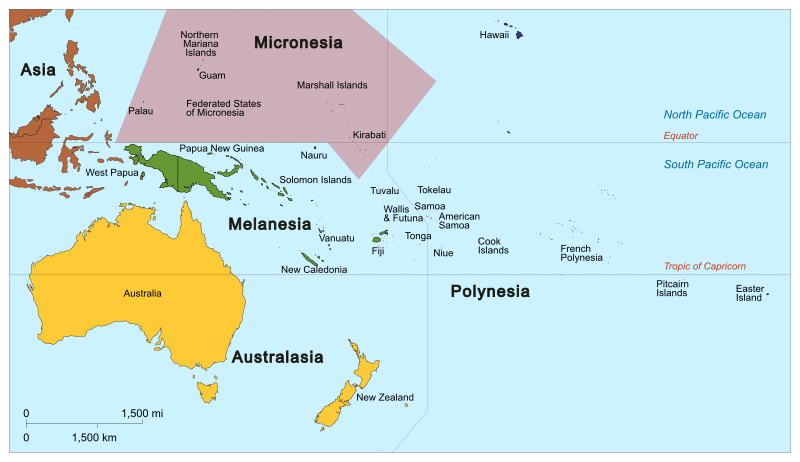
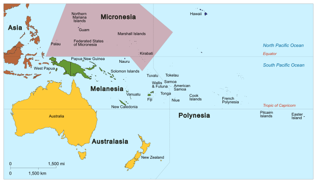
English: Map of Micronesia based on the United Nations geoscheme M49 coding classification devised by the United Nations Statistics Division. SVG format. |
| Date | |
| Source | Own work, derivative of Oceania_ISO_3166-1.svg |
| Author |
|
| Other versions |
|


Licensing
I, the copyright holder of this work, hereby publish it under the following license:
This file is licensed under the Creative Commons Attribution-Share Alike 3.0 Unported license.
- You are free:
- to share – to copy, distribute and transmit the work
- to remix – to adapt the work
- Under the following conditions:
- attribution – You must give appropriate credit, provide a link to the license, and indicate if changes were made. You may do so in any reasonable manner, but not in any way that suggests the licensor endorses you or your use.
- share alike – If you remix, transform, or build upon the material, you must distribute your contributions under the same or compatible license as the original.
File history
Click on a date/time to view the file as it appeared at that time.
| Date/Time | Thumbnail | Dimensions | User | Comment | |
|---|---|---|---|---|---|
| current | 04:17, 30 January 2014 | | 900 × 520 (519 KB) | Cruickshanks | User created page with UploadWizard |
File usage
More than 100 pages use this file. The following list shows the first 100 pages that use this file only. A full list is available.
- User:Buaidh/Test4
- User:Commonwealth1333
- User:CzechOut
- User:FallingGravity
- User:Kokobird
- User:Wabba The I/Userboxes
- User:Ziraro
- Wikipedia:Userboxes/Location
- Wikipedia:Userboxes/Location/Oceania
- Wikipedia:Userboxes/Travel
- Wikipedia:Userboxes/Travel/Countries/03
- Wikipedia:WikiProject Micronesia
- Template:User Federated States of Micronesia/doc1
- Template:User Guam/doc1
- Template:User Guam WG
- Template:User Kiribati/doc1
- Template:User Marshall Islands/doc1
- Template:User Nauru/doc1
- Template:User Northern Mariana Islands/doc1
- Template:User Northern Mariana Islands WG
- Template:User Palau/doc1
- Template:User WP Federated States of Micronesia
- Template:User WP Federated States of Micronesia/doc
- Template:User WP Kiribati
- Template:User WP Kiribati/doc
- Template:User WP Marshall Islands
- Template:User WP Marshall Islands/doc
- Template:User WP Micronesia
- Template:User WP Micronesia/doc
- Template:User WP Nauru
- Template:User WP Nauru/doc
- Template:User WP Palau
- Template:User WP Palau/doc
- Template:User citizen Federated States of Micronesia
- Template:User citizen Federated States of Micronesia/doc
- Template:User citizen Guam
- Template:User citizen Guam/doc
- Template:User citizen Kiribati
- Template:User citizen Kiribati/doc
- Template:User citizen Marshall Islands
- Template:User citizen Marshall Islands/doc
- Template:User citizen Nauru
- Template:User citizen Nauru/doc
- Template:User citizen Northern Mariana Islands
- Template:User citizen Northern Mariana Islands/doc
- Template:User citizen Palau
- Template:User citizen Palau/doc
- Template:User from Guam
- Template:User from Guam/doc
- Template:User from Kiribati
- Template:User from Kiribati/doc
- Template:User from Nauru
- Template:User from Nauru/doc
- Template:User from Palau
- Template:User from Palau/doc
- Template:User from the Federated States of Micronesia
- Template:User from the Federated States of Micronesia/doc
- Template:User from the Marshall Islands
- Template:User from the Marshall Islands/doc
- Template:User from the Northern Mariana Islands
- Template:User from the Northern Mariana Islands/doc
- Template:User in Guam
- Template:User in Guam/doc
- Template:User in Kiribati
- Template:User in Kiribati/doc
- Template:User in Micronesia
- Template:User in Nauru
- Template:User in Nauru/doc
- Template:User in Palau
- Template:User in Palau/doc
- Template:User in the Federated States of Micronesia
- Template:User in the Federated States of Micronesia/doc
- Template:User in the Marshall Islands
- Template:User in the Marshall Islands/doc
- Template:User in the Northern Mariana Islands
- Template:User in the Northern Mariana Islands/doc
- Template:User interest Federated States of Micronesia
- Template:User interest Federated States of Micronesia/doc
- Template:User interest Guam
- Template:User interest Guam/doc
- Template:User interest Kiribati
- Template:User interest Kiribati/doc
- Template:User interest Marshall Islands
- Template:User interest Marshall Islands/doc
- Template:User interest Micronesia
- Template:User interest Micronesia/doc
- Template:User interest Nauru
- Template:User interest Nauru/doc
- Template:User interest Northern Mariana Islands
- Template:User interest Northern Mariana Islands/doc
- Template:User interest Palau
- Template:User interest Palau/doc
- Template:User proud Guamanian
- Template:User proud Guamanian/doc
- Template:User proud Mariana Islander
- Template:User proud Mariana Islander/doc
- Template:User visited Guam
- Template:User visited Guam/doc
- Template:User visited the Northern Mariana Islands
- Template:User visited the Northern Mariana Islands/doc
View more links to this file.
Global file usage
The following other wikis use this file:
- Usage on af.wikipedia.org
- Usage on am.wikipedia.org
- Usage on avk.wikipedia.org
- Usage on bcl.wikipedia.org
- Usage on bg.wikipedia.org
- Usage on fi.wikipedia.org
- Usage on fr.wikipedia.org
- Fidji
- Indonésie
- Nouvelle-Zélande
- Hawaï
- Océanie
- Kiribati
- Polynésie
- Polynésie française
- Nauru
- Tuvalu
- Tonga
- Vanuatu
- Samoa
- Îles Salomon
- Papouasie-Nouvelle-Guinée
- États fédérés de Micronésie
- Guam
- Mélanésie
- Îles Pitcairn
- Projet:Géographie/Palettes de navigation
- Îles Marshall
- Niue
- Île de Pâques
- Tokelau
- Micronésie (région)
- Îles Cook
- Catégorie:Pays en Océanie
- Île Norfolk
- Îles Mariannes du Nord
- Samoa américaines
- Moluques
- Île Christmas (Australie)
- Îles mineures éloignées des États-Unis
- Îles Cocos
- Îles Ashmore-et-Cartier
- Modèle:Palette Pays d'Océanie
- Australasie
- Économie des Kiribati
- Îles Midway
- Wake (atoll)
- Îles de la mer de Corail
- Nouvelle-Calédonie
- Nouvelle-Guinée occidentale
- Australie
View more global usage of this file.