
File:Observatoire de Peking.jpg

Size of this preview: 800 × 555 pixels. Other resolutions: 320 × 222 pixels | 640 × 444 pixels | 1,024 × 710 pixels | 1,280 × 888 pixels | 2,560 × 1,775 pixels | 6,151 × 4,265 pixels.
Original file (6,151 × 4,265 pixels, file size: 3.73 MB, MIME type: image/jpeg)
| This is a file from the Wikimedia Commons. Information from its description page there is shown below. Commons is a freely licensed media file repository. You can help. |
Summary
| Description |
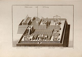
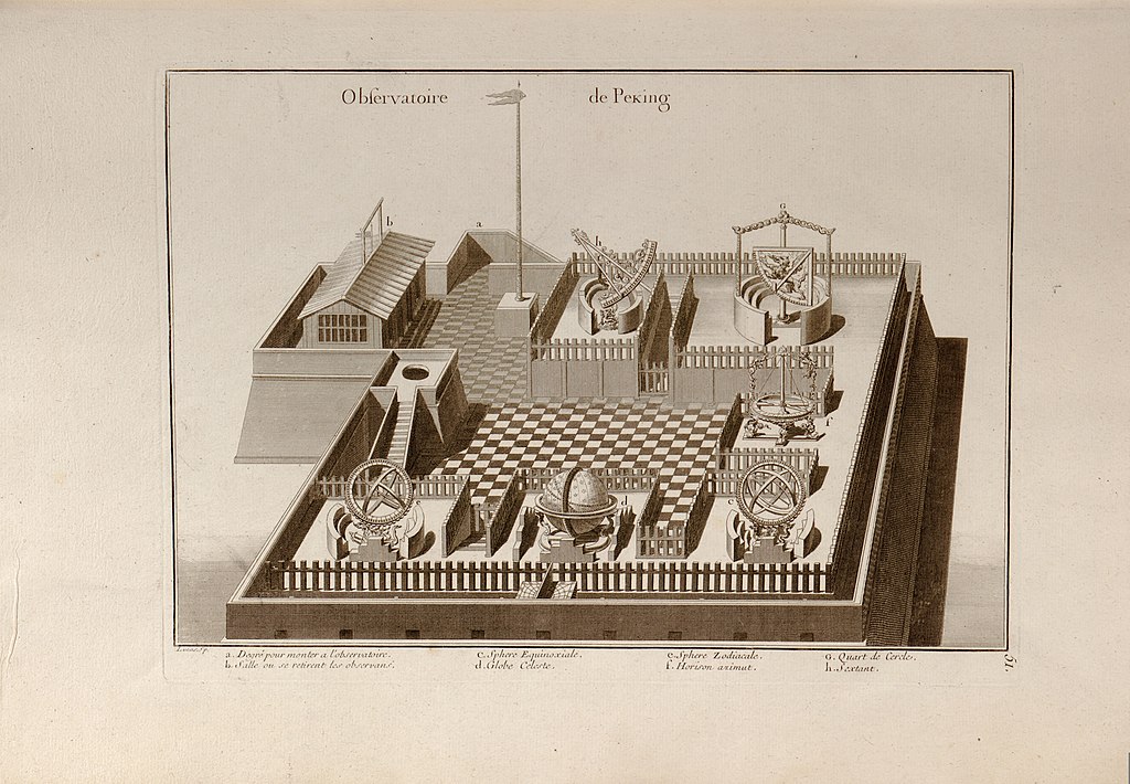
Français : Atlas général de la Chine, de la Tartarie chinoise, et du Tibet : pour servir aux différentes descriptions et histoires de cet empire / par M. d'Anville, premier géographe du roi. Rev. ed. of: Nouvel atlas de la Chine, de la Tartarie chinoise et du Thibet. 1737. C'est une copie en miroir d'un dessin du père Louis Le Comte (« Peut-être que votre altesse sera bien aise d'en voir tout d'un coup la disposition dans une figure. Le dessin que j'en ai fait… »), publié en 1696 dans le tome I de ses Nouveaux mémoires sur l'état présent de la Chine.
English: General Atlas of China, Chinese Tartary, and Tibet: to serve the various descriptions and histories of this empire / by M. d'Anville, first geographer to the king. Rev. ed. of: New Atlas of China, Chinese Tartary and Tibet. 1737. This is a mirror copy of a drawing by Father Louis Le Comte ("Perhaps your highness will be very glad to see all of a sudden the layout of it in a figure. The drawing that I have done…”), published in 1696 in volume I of his New memoirs on the present state of China. |
||
| Date | between 1697 and 1782 | ||
| Source | https://www.loc.gov/resource/g7820m.gct00075/?q=&st=gallery | ||
| Author | Anville, Jean Baptiste Bourguignon d' | ||
| Permission (Reusing this file) |
|

Licensing
This work is in the public domain in the United States because it is a work prepared by an officer or employee of the United States Government as part of that person’s official duties under the terms of Title 17, Chapter 1, Section 105 of the US Code.
Note: This only applies to original works of the Federal Government and not to the work of any individual U.S. state, territory, commonwealth, county, municipality, or any other subdivision. This template also does not apply to postage stamp designs published by the United States Postal Service since 1978. (See § 313.6(C)(1) of Compendium of U.S. Copyright Office Practices). It also does not apply to certain US coins; see The US Mint Terms of Use.
|
 | |
| This file has been identified as being free of known restrictions under copyright law, including all related and neighboring rights. | ||
File history
Click on a date/time to view the file as it appeared at that time.
| Date/Time | Thumbnail | Dimensions | User | Comment | |
|---|---|---|---|---|---|
| current | 11:38, 23 February 2012 | | 6,151 × 4,265 (3.73 MB) | Rosemania | {{Information |Description ={{fr|1=Atlas général de la Chine, de la Tartarie chinoise, et du Tibet : pour servir aux différentes descriptions et histoires de cet empire / par M. d'Anville, premier géographe du roi. Rev. ed. of: Nouvel atlas de l... |
File usage
The following pages on the English Wikipedia use this file (pages on other projects are not listed):
Global file usage
The following other wikis use this file:
- Usage on bn.wikipedia.org
- Usage on bs.wikipedia.org
- Usage on el.wikipedia.org
- Usage on fr.wikipedia.org
- Usage on id.wikipedia.org
- Usage on it.wikipedia.org
- Usage on nl.wikipedia.org
- Usage on ro.wikipedia.org