
File:Obere Schleuse in Thun.webm
Size of this JPG preview of this WEBM file: 800 × 450 pixels. Other resolutions: 320 × 180 pixels | 640 × 360 pixels | 1,024 × 576 pixels | 1,280 × 720 pixels | 1,920 × 1,080 pixels.
Original file (WebM audio/video file, VP9/Opus, length 13 s, 1,920 × 1,080 pixels, 75.55 Mbps overall, file size: 114.46 MB)
| This is a file from the Wikimedia Commons. Information from its description page there is shown below. Commons is a freely licensed media file repository. You can help. |
Summary
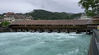
| Description | Die Obere Schleuse in Thun. Aufgenommen am Vormittag des 13. Juli 2021, kurz vor dem Eintritt des Hochwassers 2021. |
| Date | |
| Source | Own work |
| Author | Nachtbold |
| Object location | | View this and other nearby images on: OpenStreetMap |
|---|
Licensing
| This file is made available under the Creative Commons CC0 1.0 Universal Public Domain Dedication. | |
| The person who associated a work with this deed has dedicated the work to the public domain by waiving all of their rights to the work worldwide under copyright law, including all related and neighboring rights, to the extent allowed by law. You can copy, modify, distribute and perform the work, even for commercial purposes, all without asking permission.
|
File history
Click on a date/time to view the file as it appeared at that time.
| Date/Time | Thumbnail | Dimensions | User | Comment | |
|---|---|---|---|---|---|
| current | 15:35, 13 July 2021 | 13 s, 1,920 × 1,080 (114.46 MB) | Nachtbold | Imported media from uploads:9f54f42e-e3e5-11eb-8570-e263f171fcab |
File usage
The following pages on the English Wikipedia use this file (pages on other projects are not listed):
Global file usage
The following other wikis use this file:
- Usage on de.wikipedia.org
- Usage on es.wikipedia.org
- Usage on fr.wikipedia.org
- Usage on ga.wikipedia.org
- Usage on mk.wikipedia.org
- Usage on ro.wikipedia.org
- Usage on sq.wikipedia.org
- Usage on zh-yue.wikipedia.org