
File:Numbat historical map.png

Size of this preview: 663 × 600 pixels. Other resolutions: 265 × 240 pixels | 531 × 480 pixels | 849 × 768 pixels | 1,132 × 1,024 pixels | 2,000 × 1,809 pixels.
Original file (2,000 × 1,809 pixels, file size: 279 KB, MIME type: image/png)
| This is a file from the Wikimedia Commons. Information from its description page there is shown below. Commons is a freely licensed media file repository. You can help. |

|
This map image could be re-created using vector graphics as an SVG file. This has several advantages; see Commons:Media for cleanup for more information. If an SVG form of this image is available, please upload it and afterwards replace this template with
{{vector version available|new image name}}.
It is recommended to name the SVG file “Numbat historical map.svg”—then the template Vector version available (or Vva) does not need the new image name parameter. |
Summary
| Description |
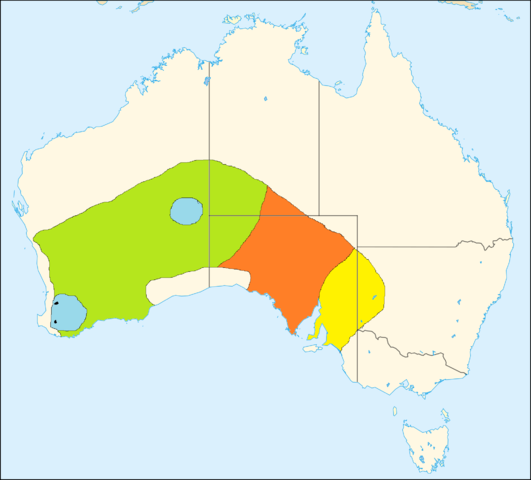
Historical range map of the numbat (Myrmecobius fasciatus) yellow: became extinct between 1800 and 1910 |
| Date | (UTC) |
| Source |
This file was derived from: AUS locator map.svg: |
| Author |
| This is a retouched picture, which means that it has been digitally altered from its original version. Modifications: added range map of numbat. The original can be viewed here: AUS locator map.svg:
|
Licensing
I, the copyright holder of this work, hereby publish it under the following licenses:
| This file is licensed under the Creative Commons Attribution-Share Alike 3.0 Unported license. | ||
| ||
| This licensing tag was added to this file as part of the GFDL licensing update. |

|
Permission is granted to copy, distribute and/or modify this document under the terms of the GNU Free Documentation License, Version 1.2 or any later version published by the Free Software Foundation; with no Invariant Sections, no Front-Cover Texts, and no Back-Cover Texts. A copy of the license is included in the section entitled GNU Free Documentation License. |
You may select the license of your choice.
Original upload log
This image is a derivative work of the following images:
- File:AUS_locator_map.svg licensed with Cc-by-sa-3.0-migrated, GFDL
- 2007-08-09T19:40:39Z Yarl 1361x1231 (130590 Bytes) {{Information |Description=Australia locator map based on [[:Image:Australia Locator Map.svg|Australia Locator Map.svg]] |Source=own rork |Date=2007 |Author=~~~ |Permission={{GFDL}} |other_versions=[[Image:Australia Locator M
Uploaded with derivativeFX
File history
Click on a date/time to view the file as it appeared at that time.
| Date/Time | Thumbnail | Dimensions | User | Comment | |
|---|---|---|---|---|---|
| current | 17:11, 22 January 2012 | | 2,000 × 1,809 (279 KB) | Baldhur | == {{int:filedesc}} == {{Information |Description=Historical range map of the numbat (''Myrmecobius fasciatus'') yellow: became extinct between 1800 and 1910<br> orange: became extinct between 1910 and 1930<br> green: became extinct between 1930 and 1960 |
File usage
The following pages on the English Wikipedia use this file (pages on other projects are not listed):
Global file usage
The following other wikis use this file:
- Usage on ceb.wikipedia.org
- Usage on de.wikipedia.org
- Usage on es.wikipedia.org
- Usage on fr.wikipedia.org