
File:Nukuoro map.png

Size of this preview: 539 × 599 pixels. Other resolutions: 216 × 240 pixels | 432 × 480 pixels | 691 × 768 pixels | 1,240 × 1,378 pixels.
Original file (1,240 × 1,378 pixels, file size: 6.53 MB, MIME type: image/png)
| This is a file from the Wikimedia Commons. Information from its description page there is shown below. Commons is a freely licensed media file repository. You can help. |
Summary
| Description |
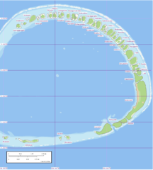
English: Nukuoro Atoll, Caroline Islands, Micronesia: Map of rim of islands (western portion of Atoll is not shown, has no islands) |
| Date | (UTC) |
| Source |
This file was derived from: |
| Author |
|
| This is a retouched picture, which means that it has been digitally altered from its original version. Modifications: Stitching. The original can be viewed here: Nukuoro North map.jpg:
|
Licensing
I, the copyright holder of this work, hereby publish it under the following license:
This file is licensed under the Creative Commons Attribution-Share Alike 3.0 Unported license.
- You are free:
- to share – to copy, distribute and transmit the work
- to remix – to adapt the work
- Under the following conditions:
- attribution – You must give appropriate credit, provide a link to the license, and indicate if changes were made. You may do so in any reasonable manner, but not in any way that suggests the licensor endorses you or your use.
- share alike – If you remix, transform, or build upon the material, you must distribute your contributions under the same or compatible license as the original.
Original upload log
This image is a derivative work of the following images:
- File:Nukuoro_North_map.jpg licensed with Cc-by-sa-3.0
- 2012-09-18T18:03:55Z Ratzer 1240x902 (284176 Bytes) {{Information |Description ={{en|1=Nukuoro Atoll, Caroline Islands, Micronesia: Map of northern rim of islands}} |Source =http://www.flickr.com/photos/evsmap/with/187885690 |Author =Peter Minton |Date
Uploaded with derivativeFX
File history
Click on a date/time to view the file as it appeared at that time.
| Date/Time | Thumbnail | Dimensions | User | Comment | |
|---|---|---|---|---|---|
| current | 23:06, 7 January 2013 | | 1,240 × 1,378 (6.53 MB) | Regi51 | == {{int:filedesc}} == {{Information |Description={{en|1=Nukuoro Atoll, Caroline Islands, Micronesia: Map of northern rim of islands}} |Source={{Derived from|Nukuoro_North_map.jpg|display=50}} |Date=2013-01-07 23:01 (UTC) |Author=*[[:File:Nukuoro_North... |
File usage
The following pages on the English Wikipedia use this file (pages on other projects are not listed):
Global file usage
The following other wikis use this file:
- Usage on ca.wikipedia.org
- Usage on de.wikipedia.org
- Usage on es.wikipedia.org
- Usage on fr.wikipedia.org
- Usage on ja.wikipedia.org
- Usage on nl.wikipedia.org
- Usage on pl.wikipedia.org
- Usage on pt.wikipedia.org
- Usage on ru.wikipedia.org
- Usage on sv.wikipedia.org
- Usage on vi.wikipedia.org
- Usage on zh.wikipedia.org