
File:NorthEastAmericaOrtelius1570.jpg

Size of this preview: 800 × 538 pixels. Other resolutions: 320 × 215 pixels | 640 × 431 pixels | 1,024 × 689 pixels | 1,497 × 1,007 pixels.
Original file (1,497 × 1,007 pixels, file size: 589 KB, MIME type: image/jpeg)
| This is a file from the Wikimedia Commons. Information from its description page there is shown below. Commons is a freely licensed media file repository. You can help. |
Summary
| Description |
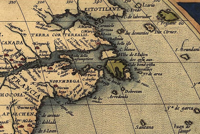
English: Northeastern part of Ortelius Americas map from 1570. (Map showing numerous more or less anachronisticly placed mythical names on locations, as well as several phantom islands, which was regular for maps in that time. For instance: Norvmbega, Terra Corterealis, Friesland, Estotiland with more.) |
| Date | |
| Source | The Library of Congress |
| Author | Ortelius, Abraham (1527–1598) |
Licensing
| I, the copyright holder of this work, release this work into the public domain. This applies worldwide. In some countries this may not be legally possible; if so: I grant anyone the right to use this work for any purpose, without any conditions, unless such conditions are required by law. |
File history
Click on a date/time to view the file as it appeared at that time.
| Date/Time | Thumbnail | Dimensions | User | Comment | |
|---|---|---|---|---|---|
| current | 19:58, 5 June 2009 | | 1,497 × 1,007 (589 KB) | Gabagool | {{Information |Description={{en|1=Northeastern part of Ortelius Americas map from 1570. (Map showing numerous more or less anachronisticly placed mythical names on locations which was regular for maps in that time. For instance: Norvmbega, Terra Cortereal |
File usage
The following pages on the English Wikipedia use this file (pages on other projects are not listed):
Global file usage
The following other wikis use this file:
- Usage on ca.wikipedia.org
- Usage on de.wikipedia.org
- Usage on fr.wikipedia.org
- Usage on it.wikipedia.org
- Usage on oc.wikipedia.org
- Usage on pl.wikipedia.org
- Usage on pt.wikipedia.org
- Usage on tr.wikipedia.org
- Usage on uk.wikipedia.org