
File:Nodaway-lewis.jpg

Original file (889 × 843 pixels, file size: 140 KB, MIME type: image/jpeg)
| This is a file from the Wikimedia Commons. Information from its description page there is shown below. Commons is a freely licensed media file repository. You can help. |
Summary
| Description |
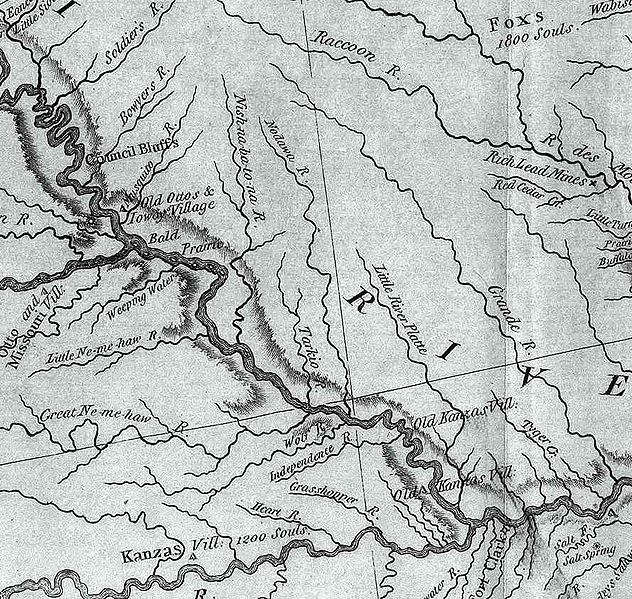
An excerpt of the Lewis and Clark Expedition map, showing a portion of the Missouri River and its tributaries.
Author: Lewis, Meriwether ; Clark, William ; Biddle, Nicholas ; Allen, Paul http://en.wikipedia.org/wiki/Image:Map_of_Lewis_and_Clark%27s_Track%2C_Across_the_Western_Portion_of_North_America%2C_published_1814.jpg Date: 1814 Short Title: Map of Lewis and Clark's Track, Across the Western Portion of North America. Publisher: Philadelphia: Bradford and Inskeep Type: Book Map Obj Height cm: 30 Obj Width cm: 70 Scale 1: 4,300,000 Note: Uncolored map showing topography and rivers in the region as well as towns, Indian villages, and population figures. Bound into the front of volume one. Reference: Howes L317; Sabin 40828; WC 13; Wheat 316. State/Province: U.S. West Full Title: A Map of Lewis and Clark's Track, Across the Western Portion of North America From the Mississippi to the Pacific Ocean; By Order of the Executive of the United States, in 1804, 5 & 6. Copied by Samuel Lewis from the Original Drawing of Wm. Clark. Smal. Harrison fct. List No: 3493.001 Series No: 2 Engraver or Printer: Lewis, Samuel ; Harrison, Samuel, 1789-1818 Publication Author: Lewis, Meriwether ; Clark, William ; Biddle, Nicholas ; Allen, Paul Pub Date: 1814 Pub Title: History Of The Expedition Under The Command Of Captains Lewis And Clark, To The Sources Of The Missouri, Thence Across The Rocky Mountains And Down The River Columbia To The Pacific Ocean. Performed During The Years 1804-5-6. By order of the Government Of The United States. Prepared For The Press By Paul Allen, Esquire. In Two Volumes. Vol. I. Philadelphia: Published By Bradford And Inskeep, New York. J. Maxwell, Printer. 1814 ... Vol. II. Pub Reference: Howes L317; Sabin 40828; WC 13; Wheat 316. Pub Note: 1st edition. Notwithstanding the title, Nicholas Biddle completed the text after Lewis's suicide. The map and the written account of the expedition changed American mapping of the northwest by giving the first accurate depiction of the relationship of the sources of the Missouri, the sources of the Columbia, and the Rocky Mountains. The map was copied by Samuel Lewis from William Clark's original drawing, and was engraved by Samuel Harrison. The title of the map is "A Map of Lewis and Clark's Track, Across the Western Portion of North America From the Mississippi to the Pacific Ocean ..." Maps are without color. In 2 volumes newly bound in full leather with the title "Lewis & Clark's Expedition ..." stamped in gilt on the spine. Pub List No: 3493.000 Pub Type: Exploration Book Pub Maps: 6 Pub Height cm: 23 Pub Width cm: 14 |
| Source | |
| Author |
Licensing
This media file is in the public domain in the United States. This applies to U.S. works where the copyright has expired, often because its first publication occurred prior to January 1, 1929, and if not then due to lack of notice or renewal. See this page for further explanation.
|
 | |
 |
This image might not be in the public domain outside of the United States; this especially applies in the countries and areas that do not apply the rule of the shorter term for US works, such as Canada, Mainland China (not Hong Kong or Macao), Germany, Mexico, and Switzerland. The creator and year of publication are essential information and must be provided. See Wikipedia:Public domain and Wikipedia:Copyrights for more details.
|
Original upload log
- 2006-06-08 03:07 Americasroof 889×843×8 (142992 bytes) This is an excerpt of the Lewis and Clark map posted to Wikipedia commons. This excerpt shows the rivers in northwest Missouri. Of particular note is the Nodawa which is the Nodaway River. Author: Lewis, Meriwether ; Clark, William ; Biddle, Nicholas ;
File history
Click on a date/time to view the file as it appeared at that time.
| Date/Time | Thumbnail | Dimensions | User | Comment | |
|---|---|---|---|---|---|
| current | 19:56, 20 September 2007 | | 889 × 843 (140 KB) | Matthiasb | {{Information |Description=This is an excerpt of the Lewis and Clark map posted to Wikipedia commons. This excerpt shows the rivers in northwest Missouri. Of particular note is the Nodawa which is the Nodaway River. Author: Lewis, Meriwether ; Clark, W |
File usage
Global file usage
The following other wikis use this file:
- Usage on ca.wikipedia.org
- Usage on de.wikipedia.org
- Usage on fr.wikipedia.org
- Usage on www.wikidata.org