
File:Ng-map.png
No higher resolution available.
Ng-map.png (329 × 352 pixels, file size: 12 KB, MIME type: image/png)
| This is a file from the Wikimedia Commons. Information from its description page there is shown below. Commons is a freely licensed media file repository. You can help. |
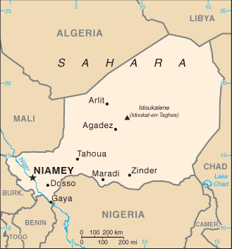
CIA map of Niger
This image is in the public domain because it contains materials that originally came from the United States Central Intelligence Agency's World Factbook.
|
 |
File history
Click on a date/time to view the file as it appeared at that time.
| Date/Time | Thumbnail | Dimensions | User | Comment | |
|---|---|---|---|---|---|
| current | 20:53, 4 March 2005 | | 329 × 352 (12 KB) | Alfio | CIA map of Niger |
File usage
The following pages on the English Wikipedia use this file (pages on other projects are not listed):
Global file usage
The following other wikis use this file:
- Usage on als.wikipedia.org
- Usage on be-tarask.wikipedia.org
- Usage on bn.wikipedia.org
- Usage on ca.wikipedia.org
- Usage on ckb.wikipedia.org
- Usage on da.wikipedia.org
- Usage on de.wikipedia.org
- Usage on dsb.wikipedia.org
- Usage on en.wikinews.org
- Usage on es.wikipedia.org
- Usage on eu.wikipedia.org
- Usage on fa.wikipedia.org
- Usage on fi.wikipedia.org
- Usage on fi.wikivoyage.org
- Usage on gl.wikipedia.org
- Usage on he.wikipedia.org
- Usage on hif.wikipedia.org
- Usage on hu.wikipedia.org
- Usage on hu.wiktionary.org
- Usage on hy.wikipedia.org
- Usage on io.wikipedia.org
- Usage on it.wikipedia.org
- Usage on lfn.wikipedia.org
- Usage on mdf.wikipedia.org
- Usage on mr.wikipedia.org
- Usage on ms.wikipedia.org
- Usage on nds-nl.wikipedia.org
- Usage on nds.wikipedia.org
- Usage on no.wikipedia.org
- Usage on pl.wikipedia.org
- Usage on ps.wikipedia.org
- Usage on pt.wikipedia.org
- Usage on ru.wikipedia.org
- Usage on sg.wikipedia.org
- Usage on sg.wiktionary.org
- Usage on si.wikipedia.org
- Usage on sq.wikipedia.org
- Usage on sr.wikipedia.org
- Usage on stq.wikipedia.org
- Usage on sw.wikipedia.org
- Usage on te.wikipedia.org
- Usage on th.wikipedia.org
View more global usage of this file.