File:New York, New York 1955 Yellow Book.jpg

Page contents not supported in other languages.
This is a file from the Wikimedia Commons
From Wikipedia, the free encyclopedia

Original file(800 × 833 pixels, file size: 226 KB, MIME type: image/jpeg)

Description
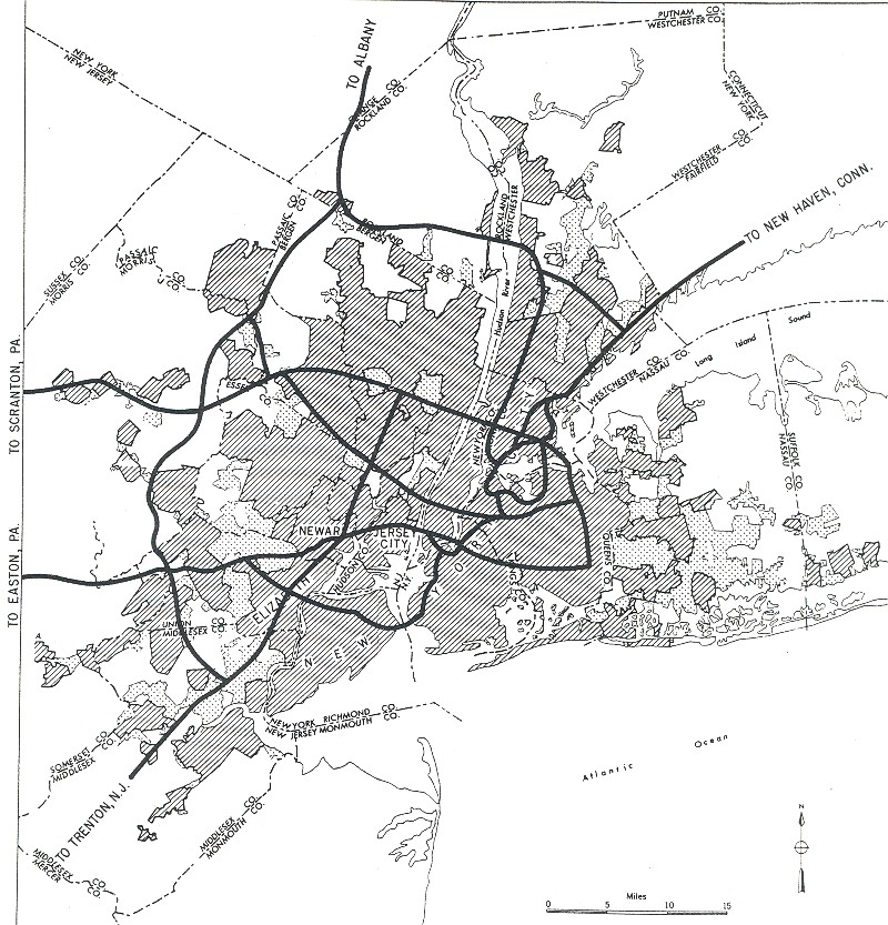
English: ;Interstates in today's terms
  • I-78 (only built west of downtown, except for several renumbered sections)
  • I-80
  • I-87
  • I-95
  • I-278 (only built east of roughly I-95)
  • I-280 (built further south, and the connection between I-280 and I-287 was never built)
  • I-287
  • I-295 (built north of Hillside Avenue as I-78)
  • I-478 (not built)
  • I-495 (west of I-295; the part west of I-278 was not completed and is now NJ 495 and NY 495)
  • I-678 (built further east)
  • I-878 (built as I-78)
  • I-895 (built south of I-95)
Date
Source
This file is a direct scan by Adam Froehlig from the following book:

Bureau of Public Roads (September 1955). "New York and environs" (Map). General Location of National System of Interstate Highways Including All Additional Routes at Urban Areas Designated in September 1955 Scale not given. Washington, DC: Government Printing Office. p. 59. OCLC 4165975.
The Bureau of Public Roads (BPR) was originally a part of the United States Department of Agriculture then the United States Department of Commerce.
The BPR is the predecessor agency to the Federal Highway Administration, a part of the United States Department of Transportation.


This tag does not indicate the copyright status of the attached work. A normal copyright tag is still required. See Commons:Licensing for more information.

Author Public Roads Administration - Federal Works Agency (predecessor to the United States Department of Transportation).
Permission
(Reusing this file)
Public domain
This image or file is a work of a United States Department of Commerce employee, taken or made as part of that person's official duties. As a work of the U.S. federal government, the image is in the public domain.

Deutsch  English  Tiếng Việt  македонски  русский  українська  日本語  +/−

File history

Click on a date/time to view the file as it appeared at that time.

Date/TimeThumbnailDimensionsUserComment
current09:29, 25 December 2005Thumbnail for version as of 09:29, 25 December 2005800 × 833 (226 KB)SPUI~commonswiki{{PD-USGov}} City map from the 1955 "Yellow Book" of Interstate Highway System plans, from [http://www.ajfroggie.com/roads/yellowbook/]. Category:1955 Yellow Book maps
The following pages on the English Wikipedia use this file (pages on other projects are not listed):

Global file usage

Metadata