
File:New Geographic Map of the Interior of Malaca WDL972.png

Size of this preview: 790 × 600 pixels. Other resolutions: 316 × 240 pixels | 632 × 480 pixels | 1,012 × 768 pixels | 1,047 × 795 pixels.
Original file (1,047 × 795 pixels, file size: 1.63 MB, MIME type: image/png)
| This is a file from the Wikimedia Commons. Information from its description page there is shown below. Commons is a freely licensed media file repository. You can help. |
Summary
| Author |
Русский: Годинью де Ередиа, Мануэль (1563-1623)
Français : Godinho de Eredia, Manuel (1563-1623)
English: Godinho de Eredia, Manuel (1563-1623)
中文:哥迪赫·德·艾勒迪亚, 曼努埃尔 (1563-1623)
Português: Godinho de Eredia, Manuel (1563-1623)
العربية: جودينهو دي إريديا, مانويل (1563-1623)
Español: Godinho de Eredia, Manuel (1563-1623) |
| Title |
Русский: Новая географическая карта внутренних районов города Малака
Français : Nouvelle Carte Géographique de l'intérieur de Malaca
English: New Geographic Map of the Interior of Malaca
中文:马六甲内陆的新地形图
Português: Novo Mapa Geográfico do Interior de Malaca
العربية: خريطة جغرافية جديدة للقسم الداخلي لملقا
Español: Nuevo mapa geográfico del interior de Malaca |
| Description |
Русский: Данная карта, на котрой изображен Малаккский пролив и внутренние регионы полуострова Малакка, была составлена малазийско-португальским картографом Эмануэлем Годиньо де Эредиа (1563-1623 гг.). На рубеже XVII века португальцы отправлялись для исследования Юго-Восточной Азии из своего опорного пункта на полуострове Малакка в попытках найти "Золотой остров", о котором говорилось во многих малайзийских легендах и сказаниях. Около 1602 года наместник короля в португальской Индии распорядился отправить экспедицию вокруг островов, расположенных к югу от Малайзии и Индии. Эредиа служил солдатом и инженером при этой экспедиции и завершил составление этой карты примерно в то же время. Однако существуют предположения, что его работа основывается в значительно большей степени на трудах Птолемея и Марко Поло, нежели на его собственном опыте.
Français : Cette carte montrant le détroit de Malacca et l'intérieur de la péninsule malaise est l'oeuvre du cartographe malaiso-portugais Emanuel Godinho de Eredia (1563-1623). A l'aube du XVIIe siècle, les Portugais exploraient l'Asie du Sud-Est à partir de leur base de Malacca, à la recherche des "Îles d'Or" que mentionnaient de nombreuses légendes malaises. Vers 1602, le Vice-roi de l'Inde portugaise commandite une expédition autour des îles au sud de la Malaisie et de l'Inde. Eredia, engagé en tant que soldat et ingénieur sur la mission, a dessiné cette carte au cours de celle-ci. On soupçonne cependant que son œuvre se fonde davantage sur les écrits de Ptolémée et de Marco Polo que sur sa propre expérience.
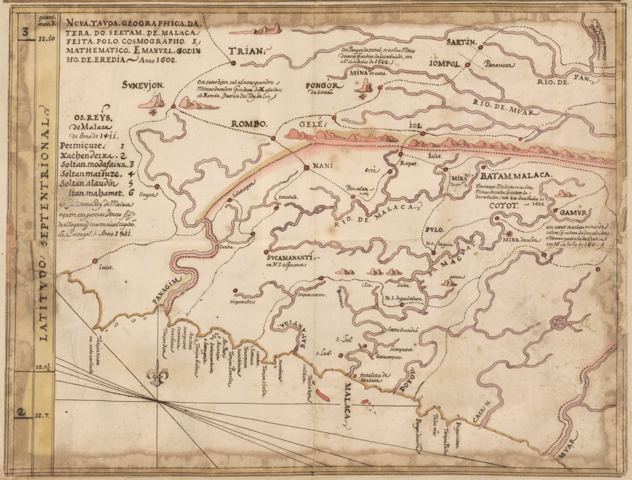
English: This map showing the Strait of Malacca and the interior of the Malay Peninsula is the work of Malaysian-Portuguese cartographer Emanuel Godinho de Eredia (1563-1623). At the turn of the 17th century, the Portuguese were exploring southeast Asia from their base in Malacca, searching for the “Islands of Gold” that figured prominently in Malaysian legends. Around 1602, the viceroy of Portuguese India commissioned an expedition around the islands south of Malaysia and India. Eredia served as a soldier and engineer on the mission and completed this map around the same time. His work, however, is suspected to be based more on the writings of Ptolemy and Marco Polo than on his own experience.
中文:这幅描绘马六甲海峡与马来半岛内陆的地图出自一名马来西亚-葡萄牙籍制图师伊曼纽尔·戈迪尼奥·德·埃雷迪亚(1563-1623 年)。 17 世纪末 18 世纪初,葡萄牙人欲从其马六甲基地扩张到东南亚,寻找在马来西亚传说中广为传颂的“金岛”。 约在 1602 年,葡属印度总督委派探险队对马来西亚与印度南部的岛屿进行勘察。 埃雷迪亚是其中的一名士兵与工程师,约在这一时期完成了这幅地图。 然而,他的作品被怀疑与其亲身经历相比,更多地参照了托勒密和马可波罗的著作。
Português: Este mapa que mostra o Estreito de Malacca e o interior da Península de Malaia é obra do cartógrafo Português-Malaio Emanuel Godinho de Eredia (1563-1623). Na virada do século XVII, o Português estava explorando o Sudeste Asiático da sua base em Malacca, buscando pelas "Ilhas do Ouro" que figuravam proeminentemente nas lendas Malasianas. Por volta de 1602, o vice-rei da Índia Portuguesa encomendou uma expedição ao redor das ilhas ao sul da Malasia e da Índia. Eredia serviu como soldado e engenheiro na missão e concluiu este mapa ao redor do mesmo tempo. Sua obra, porém, é suspeita de se basear mais nos escritos de Ptolomeu e Marco Polo do que na sua própria experiência.
العربية: أعد هذه الخريطة، التي تبين مضيق ملقا والمناطق الداخلية من شبه جزيرة الملايو، رسام الخرائط الماليزي البرتغالي ايمانويل جودينهو دي إريديا (1563-1623). وفي مطلع القرن السابع عشر، كان البرتغاليون منشغلون في استكشاف جنوب شرق آسيا انطلاقا من قاعدتهم في ملقا، بحثاً عن "جزر الذهب" التي ورد ذكرها كثيرًا في الأساطير الماليزية. وفي حوالي عام 1602، اطلق نائب الملك للهند البرتغالية بعثة استكشافية حول الجزر في جنوب ماليزيا والهند. وقد عمل اريديا كجندي ومهندس في البعثة، وأنهى هذه الخريطة في نفس الوقت تقريبا. ومع ذلك، يُشتبه في أن يكون قد اعتمد في عمله على كتابات بطليموس وماركو بولو أكثر من اعتماده على تجربته الخاصة.
Español: Este mapa, que muestra el Estrecho de Malaca y el interior de la península malaya. Es obra del cartógrafo malayo-portugués Emanuel Godinho de Eredia (1563-1623). En el umbral del siglo XVII, los portugueses estaban explorando el sureste de Asia desde su base en Malaca en busca de las «Islas de Oro» que ocuparon un lugar destacado en las leyendas de Malasia. Alrededor de 1602, el virrey de la India portuguesa encomendó una expedición alrededor de las islas al sur de Malasia y la India. Eredia prestó servicio como soldado e ingeniero de la misión y completó este mapa al mismo tiempo. Sin embargo, se sospecha que su obra se basa más en los escritos de Ptolomeo y Marco Polo, que en su propia experiencia. |
| Date | 1602 |
| Medium |
Русский: Карты
Français : Cartes
English: Maps
中文:地图
Português: Mapas
العربية: خرائط
Español: Mapas |
| Dimensions |
English: 1 pen-and-ink and watercolor manuscript map ; 30 x 39.5 centimeters |
| Collection |
Русский: Национальная библиотека Бразилии
Français : Bibliothèque nationale du Brésil
English: National Library of Brazil
中文:巴西国家图书馆
Português: Biblioteca Nacional do Brasil
العربية: مكتبة البرازيل الوطنية
Español: Biblioteca Nacional de Brasil |
| Place of creation |
Русский: Малакка
Français : Malacca
English: Malacca
中文:马六甲
Português: Melaka
العربية: ملقا
Español: Malaca |
| Notes | Original language title: Nova tavoa geographica da tera do sertam de Malaca |
| References | http://hdl.loc.gov/loc.wdl/brrjbn.972 |
| Source/Photographer |
|
Licensing
|
This is a faithful photographic reproduction of a two-dimensional, public domain work of art. The work of art itself is in the public domain for the following reason:
The official position taken by the Wikimedia Foundation is that "faithful reproductions of two-dimensional public domain works of art are public domain".
This photographic reproduction is therefore also considered to be in the public domain in the United States. In other jurisdictions, re-use of this content may be restricted; see Reuse of PD-Art photographs for details. | ||||
File history
Click on a date/time to view the file as it appeared at that time.
| Date/Time | Thumbnail | Dimensions | User | Comment | |
|---|---|---|---|---|---|
| current | 11:55, 15 July 2017 | | 1,047 × 795 (1.63 MB) | Hzh | trimmed to focus on map |
| 04:53, 12 March 2014 |  | 1,470 × 1,024 (2.75 MB) | Fæ | =={{int:filedesc}}== {{Artwork |artist = |author ={{ru|1=Годинью де Ередиа, Мануэль (1563-1623)}} {{fr|1=Godinho de Eredia, Manuel (1563-1623)}} {{en|1=Godinho de Eredia, Manuel (1563-1623)}} {{zh|1=哥迪赫·德·艾勒迪亚,... |
File usage
The following pages on the English Wikipedia use this file (pages on other projects are not listed):
Global file usage
The following other wikis use this file:
- Usage on fr.wikipedia.org
- Usage on id.wikipedia.org
- Usage on ms.wikipedia.org
- Usage on pt.wikipedia.org