
File:New Caledonia and Vanuatu bathymetric and topographic map-fr.svg

Size of this PNG preview of this SVG file: 800 × 561 pixels. Other resolutions: 320 × 224 pixels | 640 × 449 pixels | 1,024 × 718 pixels | 1,280 × 898 pixels | 2,560 × 1,795 pixels | 2,980 × 2,090 pixels.
Original file (SVG file, nominally 2,980 × 2,090 pixels, file size: 4.3 MB)
| This is a file from the Wikimedia Commons. Information from its description page there is shown below. Commons is a freely licensed media file repository. You can help. |
Summary
| Description |
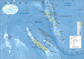
English: Bathymetric and topographic map of New Caledonia and Vanuatu, Oceania.
Note: The background map is a raster image embedded in the SVG file. Français : Carte bathymétrique et topographqiue de la Nouvelle-Calédonie et de Vanuatu, Océanie.
Note : Le fond de carte est une image bitmap embarquée dans le fichier SVG.
|
||
| Date | ; revision 2013-12 | ||
| Source |
Own work ;
|
||
| Author | Eric Gaba (Sting - fr:Sting) | ||
| Permission (Reusing this file) |
|
||
| Other versions |
[]
Administrative and simplified version:
|


| Camera location | | View this and other nearby images on: OpenStreetMap |
|---|
Licensing
I, the copyright holder of this work, hereby publish it under the following licenses:

|
Permission is granted to copy, distribute and/or modify this document under the terms of the GNU Free Documentation License, Version 1.2 or any later version published by the Free Software Foundation; with no Invariant Sections, no Front-Cover Texts, and no Back-Cover Texts. A copy of the license is included in the section entitled GNU Free Documentation License. |
This file is licensed under the Creative Commons Attribution-Share Alike 4.0 International, 3.0 Unported, 2.5 Generic, 2.0 Generic and 1.0 Generic license.
- You are free:
- to share – to copy, distribute and transmit the work
- to remix – to adapt the work
- Under the following conditions:
- attribution – You must give appropriate credit, provide a link to the license, and indicate if changes were made. You may do so in any reasonable manner, but not in any way that suggests the licensor endorses you or your use.
- share alike – If you remix, transform, or build upon the material, you must distribute your contributions under the same or compatible license as the original.
You may select the license of your choice.
File history
Click on a date/time to view the file as it appeared at that time.
| Date/Time | Thumbnail | Dimensions | User | Comment | |
|---|---|---|---|---|---|
| current | 17:39, 19 December 2013 | | 2,980 × 2,090 (4.3 MB) | Sting | Île de Sable removed (cf http://www.shom.fr/fileadmin/data-www/DMI/Communiques_de_presse/2012/COMMUNIQUE-DE-PRESSE-SANDY-ISLAND.doc) ; new elevation data used (SRTM30 Plus) |
| 03:08, 17 February 2009 |  | 2,980 × 2,090 (1.47 MB) | Sting | == Summary == {{Location|18|30|00|S|166|00|00|E|scale:10000000}} <br/> {{Information |Description={{en|Bathymetric and topographic map of New Caledonia and Vanuatu, Oceania.}} {{fr|Carte bathymétrique |
File usage
The following pages on the English Wikipedia use this file (pages on other projects are not listed):
Global file usage
The following other wikis use this file:
- Usage on af.wikipedia.org
- Usage on als.wikipedia.org
- Usage on bn.wikipedia.org
- Usage on cs.wikipedia.org
- Usage on da.wikipedia.org
- Usage on de.wikipedia.org
- Usage on eo.wikipedia.org
- Usage on fr.wikipedia.org
- Usage on ja.wikipedia.org
- Usage on www.wikidata.org