
File:Nepartak 2016-07-07 0230Z.jpg

Size of this preview: 450 × 600 pixels. Other resolutions: 180 × 240 pixels | 360 × 480 pixels | 576 × 768 pixels | 768 × 1,024 pixels | 1,536 × 2,048 pixels | 6,300 × 8,400 pixels.
Original file (6,300 × 8,400 pixels, file size: 13.94 MB, MIME type: image/jpeg)
| This is a file from the Wikimedia Commons. Information from its description page there is shown below. Commons is a freely licensed media file repository. You can help. |
Summary
| Description |
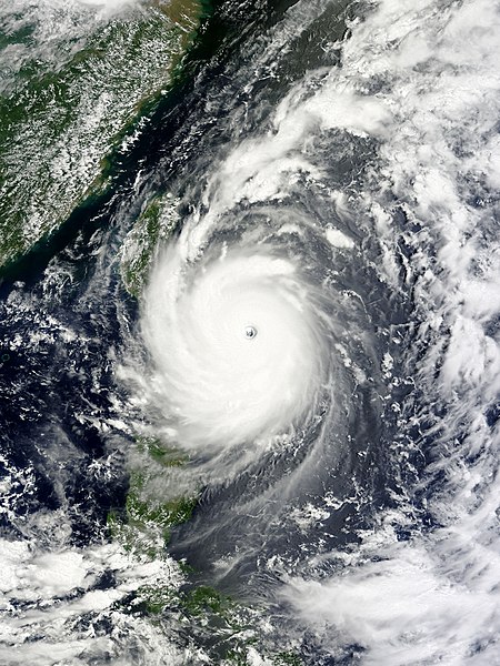
English: Typhoon Nepartak at peak intensity and approaching Taiwan on July 7, 2016. 中文(臺灣):颱風尼伯特2016年7月7日位處巔峰且逼近台灣。 |
| Date | |
| Source | EOSDIS Worldview |
| Author | MODIS image captured by NASA’s Terra satellite |
| Other versions |
|
.jpg)
| Camera location | | View this and other nearby images on: OpenStreetMap |
|---|
Licensing
| This file is in the public domain in the United States because it was solely created by NASA. NASA copyright policy states that "NASA material is not protected by copyright unless noted". (See Template:PD-USGov, NASA copyright policy page or JPL Image Use Policy.) | ||
 |
Warnings:
|
File history
Click on a date/time to view the file as it appeared at that time.
| Date/Time | Thumbnail | Dimensions | User | Comment | |
|---|---|---|---|---|---|
| current | 12:21, 7 July 2016 | | 6,300 × 8,400 (13.94 MB) | Meow | Optimised. |
| 05:19, 7 July 2016 |  | 6,353 × 8,417 (5.68 MB) | Meow | User created page with UploadWizard |
File usage
The following pages on the English Wikipedia use this file (pages on other projects are not listed):
Global file usage
The following other wikis use this file:
- Usage on es.wikipedia.org
- Usage on pt.wikipedia.org
- Usage on zh.wikipedia.org
- Usage on zh.wikinews.org