
File:Naval Station Sangley Point aerial1 c1964.jpg

Size of this preview: 800 × 463 pixels. Other resolutions: 320 × 185 pixels | 810 × 469 pixels.
Original file (810 × 469 pixels, file size: 248 KB, MIME type: image/jpeg)
| This is a file from the Wikimedia Commons. Information from its description page there is shown below. Commons is a freely licensed media file repository. You can help. |
Summary
| Description |
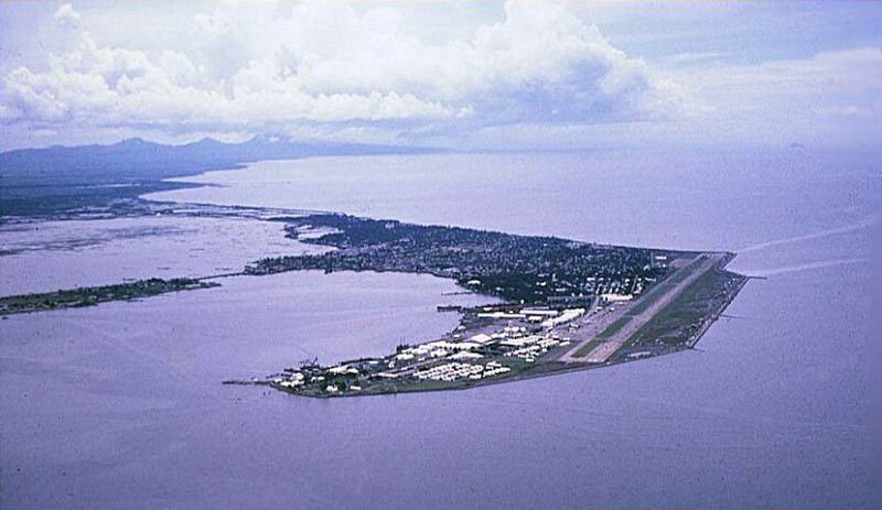
English: An aerial view of the Cavite Peninsula (circa 1963-1966) in Manila Bay, Philippines with the U.S. Naval Station Sangley Point in the foreground and Cavite City behind the base. Bacoor Bay is the body of water at the leftmost center of the picture near the mainland and Cañacao Bay is to the left of the naval base. |
| Date | circa 1963-1966 |
| Source | U.S. Navy Cdr. Bigley website [1] |
| Author | Cdr. T. L. Bigley, USNR-TAR (Retired), VP-40 1963-1966 |
| Camera location | | View this and other nearby images on: OpenStreetMap |
|---|
Licensing
This file is a work of a sailor or employee of the U.S. Navy, taken or made as part of that person's official duties. As a work of the U.S. federal government, it is in the public domain in the United States.
|
 | |
| This file has been identified as being free of known restrictions under copyright law, including all related and neighboring rights. | ||
File history
Click on a date/time to view the file as it appeared at that time.
| Date/Time | Thumbnail | Dimensions | User | Comment | |
|---|---|---|---|---|---|
| current | 21:28, 7 April 2010 | | 810 × 469 (248 KB) | Cobatfor | == {{int:filedesc}} == {{Information |Description=Aerial view of the U.S. Naval Station Sangley Point, Philippines, circa 1963-1966. |Source=U.S. Navy Cdr. Bigley website [http://home.earthlink.net/~patron40/] |Date={{other date|ca|1963-1966}} |Author=Cdr |
File usage
The following pages on the English Wikipedia use this file (pages on other projects are not listed):
Global file usage
The following other wikis use this file:
- Usage on ceb.wikipedia.org
- Usage on en.wikivoyage.org
- Usage on es.wikipedia.org
- Usage on ilo.wikipedia.org
- Usage on lv.wikipedia.org
- Usage on www.wikidata.org