
File:Narbonne - Le pont des marchands.jpg

Size of this preview: 800 × 586 pixels. Other resolutions: 320 × 234 pixels | 640 × 469 pixels | 1,024 × 750 pixels | 1,280 × 937 pixels | 2,560 × 1,874 pixels | 3,368 × 2,466 pixels.
Original file (3,368 × 2,466 pixels, file size: 3.24 MB, MIME type: image/jpeg)
| This is a file from the Wikimedia Commons. Information from its description page there is shown below. Commons is a freely licensed media file repository. You can help. |
Summary
|
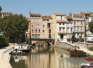
Pont des Marchands, in Narbonne, Aude department, France | |||||||||||||||||||
|
| |||||||||||||||||||


File history
Click on a date/time to view the file as it appeared at that time.
| Date/Time | Thumbnail | Dimensions | User | Comment | |
|---|---|---|---|---|---|
| current | 17:10, 2 August 2015 | | 3,368 × 2,466 (3.24 MB) | Archaeodontosaurus | {{Information |Description ={{en|1=c}} |Source ={{own}} |Author =Archaeodontosaurus |Date = |Permission = |other_versions = }} |
File usage
The following pages on the English Wikipedia use this file (pages on other projects are not listed):
Global file usage
The following other wikis use this file:
- Usage on ca.wikipedia.org
- Usage on de.wikipedia.org
- Usage on de.wikivoyage.org
- Usage on es.wikipedia.org
- Usage on fr.wikipedia.org
- Usage on it.wikipedia.org
- Usage on tr.wikipedia.org
- Usage on uk.wikipedia.org
- Usage on www.wikidata.org