
File:Nansen Franz Josef Land voyage map.svg

Size of this PNG preview of this SVG file: 600 × 438 pixels. Other resolutions: 320 × 234 pixels | 640 × 467 pixels | 1,024 × 748 pixels | 1,280 × 934 pixels | 2,560 × 1,869 pixels.
Original file (SVG file, nominally 600 × 438 pixels, file size: 400 KB)
| This is a file from the Wikimedia Commons. Information from its description page there is shown below. Commons is a freely licensed media file repository. You can help. |
Summary
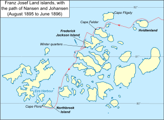
| Description | Map of Franz Josef Land archipelago in the Arctic Ocean north of Russia, showing the path of Nansen and Johansen through the islands, August 1895 to June 1896 |
| Date | |
| Source |
Vector version of File:Nansen Franz Josef Land Voyage Map.PNG This W3C-unspecified vector image was created with Inkscape . |
| Author | Dtbohrer |
| Other versions |
Derivative works of this file: Nansen Franz Josef Land voyage map-fr.svg PNG version |
Licensing
| I, the copyright holder of this work, release this work into the public domain. This applies worldwide. In some countries this may not be legally possible; if so: I grant anyone the right to use this work for any purpose, without any conditions, unless such conditions are required by law. |
File history
Click on a date/time to view the file as it appeared at that time.
| Date/Time | Thumbnail | Dimensions | User | Comment | |
|---|---|---|---|---|---|
| current | 23:17, 17 October 2009 | | 600 × 438 (400 KB) | Niagara | darken latitude lines |
| 01:33, 13 October 2009 |  | 600 × 438 (401 KB) | Niagara | == Summary == {{Information |Description = Map of Franz Josef Land archipelago in the Arctic Ocean north of Russia, showing the path of Nansen and Johansen through the islands, August 1895 to June 189 |
File usage
The following pages on the English Wikipedia use this file (pages on other projects are not listed):
Global file usage
The following other wikis use this file:
- Usage on ar.wikipedia.org
- Usage on ast.wikipedia.org
- Usage on be.wikipedia.org
- Usage on ca.wikipedia.org
- Usage on es.wikipedia.org
- Usage on fr.wikipedia.org
- Usage on hy.wikipedia.org
- Usage on it.wikipedia.org
- Usage on ja.wikipedia.org
- Usage on pt.wikipedia.org
- Usage on ro.wikipedia.org
- Usage on zh.wikipedia.org