
File:Nanking Safety Zone map.png
No higher resolution available.
Nanking_Safety_Zone_map.png (266 × 374 pixels, file size: 121 KB, MIME type: image/png)
Summary[edit]
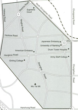
| Description | Map of the Nanking Safety Zone, which was located in the heart of the city of Nanking between 1937 and 1938 |
|---|---|
| Author or copyright owner |
probably Hualing Hu |
| Source (WP:NFCC#4) | Original publication: the book "American Goddess at the Rape of Nanking" by Hualing Hu Immediate source: page xxvii of the book "American Goddess at the Rape of Nanking" by Hualing Hu |
| Date of publication | 2000 |
| Use in article (WP:NFCC#7) | Nanking Safety Zone |
| Purpose of use in article (WP:NFCC#8) | The article on the Nanking Safety Zone would benefit from a map. |
| Not replaceable with free media because (WP:NFCC#1) |
I couldn't manage to find such an illustration though if I ever manage to come across one, I will replace this one. |
| Minimal use (WP:NFCC#3) | It ought to be used only in the article entitled "Nanking Safety Zone". |
| Respect for commercial opportunities (WP:NFCC#2) |
This map was on only one portion of one page out of the book's 184 pages, and I'm not aware that the map has ever been sold separate from the book. Therefore, sales of the book probably derive only in small measure from the map in comparison to the book's remaining 183 and one half pages. |
| Fair useFair use of copyrighted material in the context of Nanking Safety Zone//en.wikipedia.org/wiki/File:Nanking_Safety_Zone_map.pngtrue | |
Licensing[edit]
 | This image represents a two-dimensional work of art, such as a drawing, painting, print, or similar creation. The copyright for this image is likely owned by either the artist who created it, the individual who commissioned the work, or their legal heirs. It is believed that the use of low-resolution images of artworks:
qualifies as fair use under United States copyright law. Any other use of this image, whether on Wikipedia or elsewhere, could potentially constitute a copyright infringement. For further information, please refer to Wikipedia's guidelines on non-free content. |
File history
Click on a date/time to view the file as it appeared at that time.
| Date/Time | Thumbnail | Dimensions | User | Comment | |
|---|---|---|---|---|---|
| current | 05:14, 12 May 2017 | | 266 × 374 (121 KB) | DatBot (talk | contribs) | Reduce size of non-free image (BOT - disable) |
| 20:31, 4 April 2013 | No thumbnail | 459 × 646 (333 KB) | CurtisNaito (talk | contribs) | Uploading a non-free file using File Upload Wizard |
You cannot overwrite this file.
File usage
The following pages on the English Wikipedia use this file (pages on other projects are not listed):