
File:Nagoya Castle aerial photo.jpg
Size of this preview: 555 × 599 pixels. Other resolutions: 222 × 240 pixels | 445 × 480 pixels | 712 × 768 pixels | 949 × 1,024 pixels | 1,898 × 2,048 pixels | 3,078 × 3,322 pixels.
Original file (3,078 × 3,322 pixels, file size: 10 MB, MIME type: image/jpeg)
| This is a file from the Wikimedia Commons. Information from its description page there is shown below. Commons is a freely licensed media file repository. You can help. |
| Camera location | | View this and other nearby images on: OpenStreetMap |
|---|
English
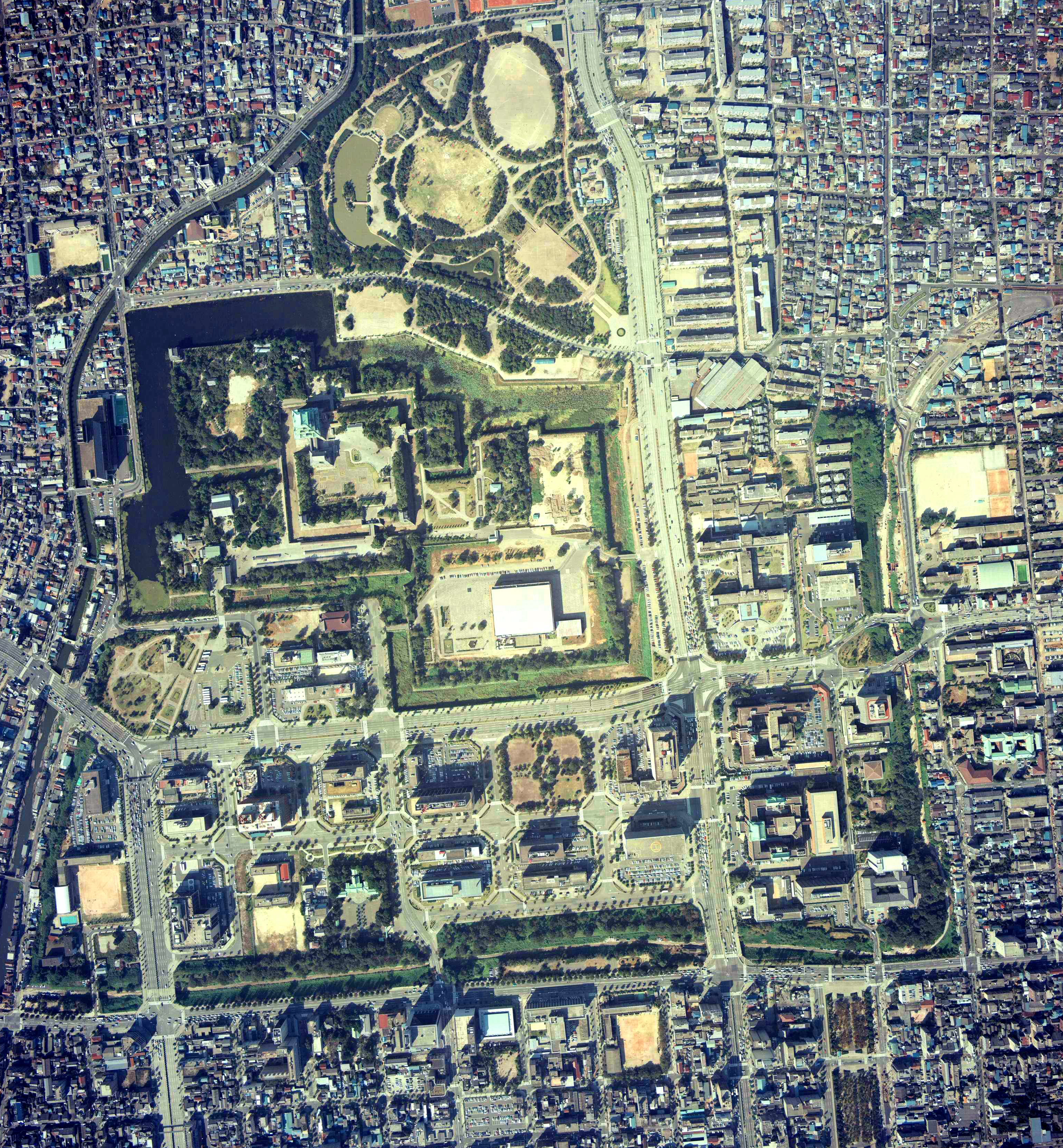
- Description: Aeral Photo of Nagoya Castle in Nagoya, Aichi, Japan
- Source: image from Country Picture Information (Color Aerial Photo) archive copy at the Wayback Machine resized by Mnd
- Date: 1977
日本語 (Japanese)
- 説明: 愛知県名古屋市にある名古屋城の空中写真
- 空中写真の北方向:

- 整理番号: CCB-77-15
- 撮影年度: 昭和52年度 (1977年度)
- 地区名: 名古屋
- 撮影縮尺: 1/8000
- 撮影コース: C14
- 写真番号: 6
- 空中写真の北方向:
- 出典: 国土画像情報 (カラー空中写真) archive copy at the Wayback Machineの写真をMndがリサイズ

|
The copyright holder of this file, the Ministry of Land, Infrastructure, Transport and Tourism of Japan, allows anyone to use it for any purpose, provided that the copyright holder is properly attributed. Redistribution, derivative work, commercial use, and all other use is permitted. |
Attribution:
Copyright © National Land Image Information (Color Aerial Photographs), Ministry of Land, Infrastructure, Transport and Tourism
|
 |
This image is copyrighted by the Ministry of Land, Infrastructure, Transport and Tourism of Japan. For terms of use, see the stipulation to use of National Land Information (in Japanese) and message from MLIT (in Japanese and English). When you display this image on an article, include the following phrase in the description: "Made based on National Land Image Information (Color Aerial Photographs), Ministry of Land, Infrastructure, Transport and Tourism".
|
File history
Click on a date/time to view the file as it appeared at that time.
| Date/Time | Thumbnail | Dimensions | User | Comment | |
|---|---|---|---|---|---|
| current | 12:12, 24 September 2020 | | 3,078 × 3,322 (10 MB) | 名古屋太郎 | Color adjustment and high definition |
| 06:59, 17 October 2017 |  | 835 × 900 (411 KB) | Togabi | Color adjustment. | |
| 04:56, 23 September 2005 |  | 780 × 840 (192 KB) | Mnd | == English == *'''Description:''' Aeral Photo of Nagoya Castle in Nagoya, Aichi, Japan *'''Source:''' image from [http://w3land.mlit.go.jp/WebGIS/ Country Picture Information (Color Aerial Photo)] resized by ~~~ *'''Date:''' 1977 *'''Permission:''' GFDL |
File usage
No pages on the English Wikipedia use this file (pages on other projects are not listed).