
File:NUTS 3 regions of Northern Ireland map.svg

Size of this PNG preview of this SVG file: 705 × 599 pixels. Other resolutions: 282 × 240 pixels | 565 × 480 pixels | 903 × 768 pixels | 1,205 × 1,024 pixels | 2,409 × 2,048 pixels | 1,208 × 1,027 pixels.
Original file (SVG file, nominally 1,208 × 1,027 pixels, file size: 163 KB)
| This is a file from the Wikimedia Commons. Information from its description page there is shown below. Commons is a freely licensed media file repository. You can help. |
Summary
| Description |
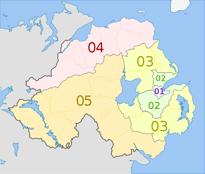
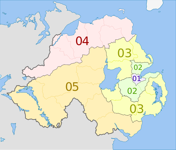
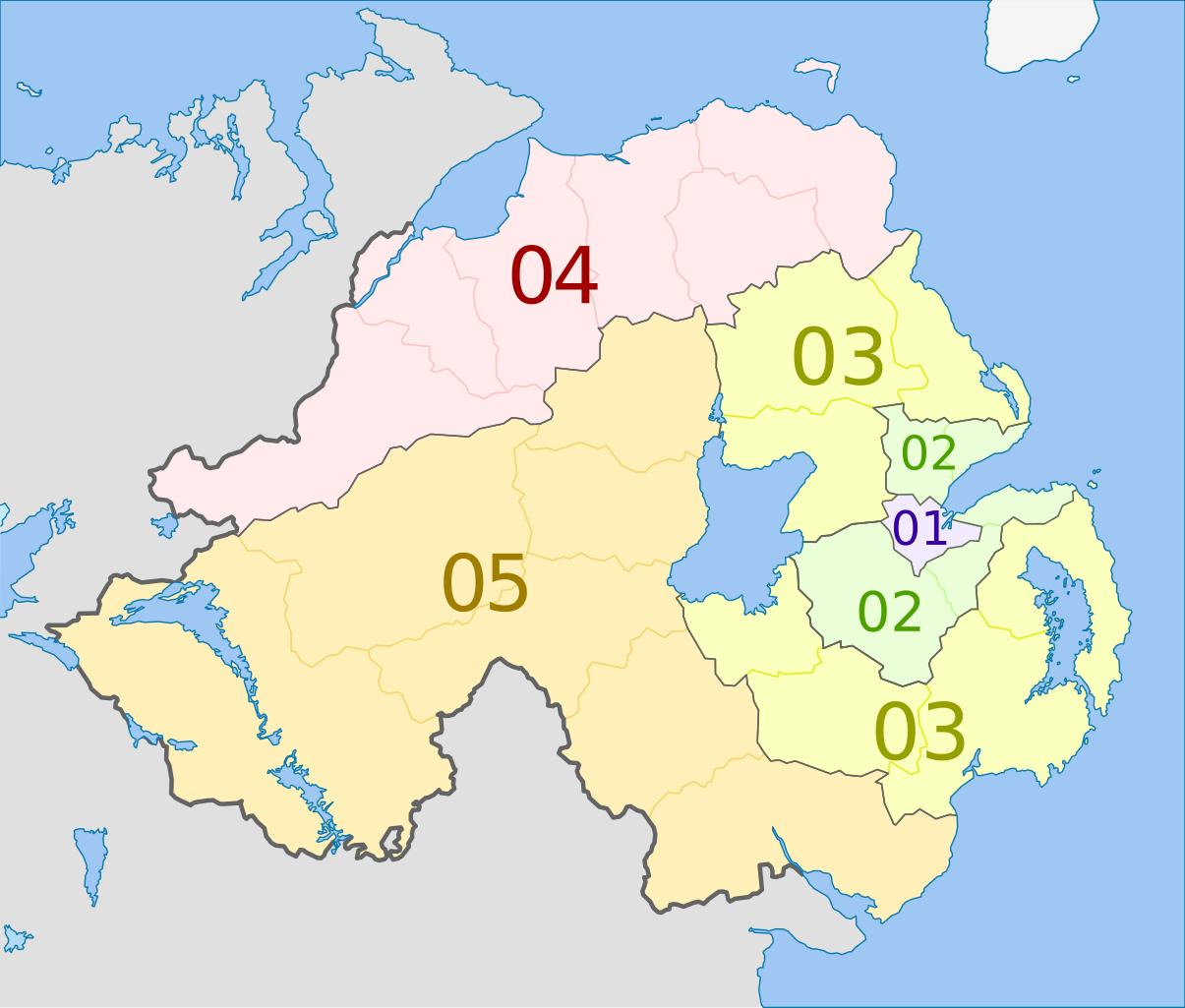
Deutsch: Karte von Nordirland: NUTS-Raumeinheiten auf den Ebenen NUTS3.
Quadratische Plattkarte, N-S-Streckung 170 %. Geographische Begrenzung der Karte:
English: Map of the NUTS 3 regions of Northern Ireland.
Equirectangular projection, N/S stretching 170 %. Geographic limits of the map:
|
| Date | (UTC) |
| Source |
This file was derived from: Northern Ireland location map.svg: |
| Author |
|
| NUTS 1 | Code | NUTS 2 | Code | NUTS 3 | Code |
|---|---|---|---|---|---|
| Northern Ireland | UKN | Northern Ireland | UKN0 | Belfast | UKN01 |
| Outer Belfast (Carrickfergus, Castlereagh, Lisburn, Newtownabbey, North Down) | UKN02 | ||||
| East of Northern Ireland (Antrim, Ards, Ballymena, Banbridge, Craigavon, Down, Larne) | UKN03 | ||||
| North of Northern Ireland (Ballymoney, Coleraine, Derry, Limavady, Moyle, Strabane) | UKN04 | ||||
| West and South of Northern Ireland (Armagh, Cookstown, Dungannon, Fermanagh, Magherafelt, Newry and Mourne, Omagh) | UKN05 |
Licensing
I, the copyright holder of this work, hereby publish it under the following license:
This file is licensed under the Creative Commons Attribution-Share Alike 3.0 Unported license.
Attribution: Dr Greg and NordNordWest
- You are free:
- to share – to copy, distribute and transmit the work
- to remix – to adapt the work
- Under the following conditions:
- attribution – You must give appropriate credit, provide a link to the license, and indicate if changes were made. You may do so in any reasonable manner, but not in any way that suggests the licensor endorses you or your use.
- share alike – If you remix, transform, or build upon the material, you must distribute your contributions under the same or compatible license as the original.
Original upload log
This image is a derivative work of the following images:
- File:Northern_Ireland_location_map.svg licensed with Cc-by-sa-3.0
- 2009-09-22T18:02:38Z NordNordWest 1208x1027 (166284 Bytes)
- 2009-07-04T20:14:31Z NordNordWest 1208x1027 (167876 Bytes)
- 2009-07-04T20:10:20Z NordNordWest 1208x1027 (167239 Bytes) {{Information |Description= {{de|Positionskarte von [[:de:Nordirland|Nordirland]]}} Quadratische Plattkarte, N-S-Streckung 170 %. Geographische Begrenzung der Karte: * N: 55.4° N * S: 53.9° N * W: 8.3° W * O: 5.3° W {{en|
Uploaded with derivativeFX
File history
Click on a date/time to view the file as it appeared at that time.
| Date/Time | Thumbnail | Dimensions | User | Comment | |
|---|---|---|---|---|---|
| current | 00:20, 5 June 2012 | | 1,208 × 1,027 (163 KB) | Dr Greg | == {{int:filedesc}} == {{Information |Description={{de|Karte von Nordirland: de:NUTS-Raumeinheiten auf den Ebenen NUTS3. Quadratische Plattkarte, N-S-Streckung 170 %. Geographische Begrenzung der Karte: * N: 55.4° N * S: ... |
File usage
The following pages on the English Wikipedia use this file (pages on other projects are not listed):
Global file usage
The following other wikis use this file:
- Usage on ar.wikipedia.org
- Usage on de.wikipedia.org
- Usage on fi.wikipedia.org
- Usage on it.wikipedia.org
- Usage on ja.wikipedia.org
- Usage on lt.wikipedia.org
- Usage on ru.wikipedia.org
- Usage on uk.wikipedia.org
- Usage on zh.wikipedia.org