
File:Moruroa atoll.JPG
Size of this preview: 800 × 527 pixels. Other resolutions: 320 × 211 pixels | 640 × 422 pixels | 1,024 × 675 pixels | 1,280 × 844 pixels | 3,032 × 1,999 pixels.
Original file (3,032 × 1,999 pixels, file size: 1.01 MB, MIME type: image/jpeg)
| This is a file from the Wikimedia Commons. Information from its description page there is shown below. Commons is a freely licensed media file repository. You can help. |
Summary
| Description |
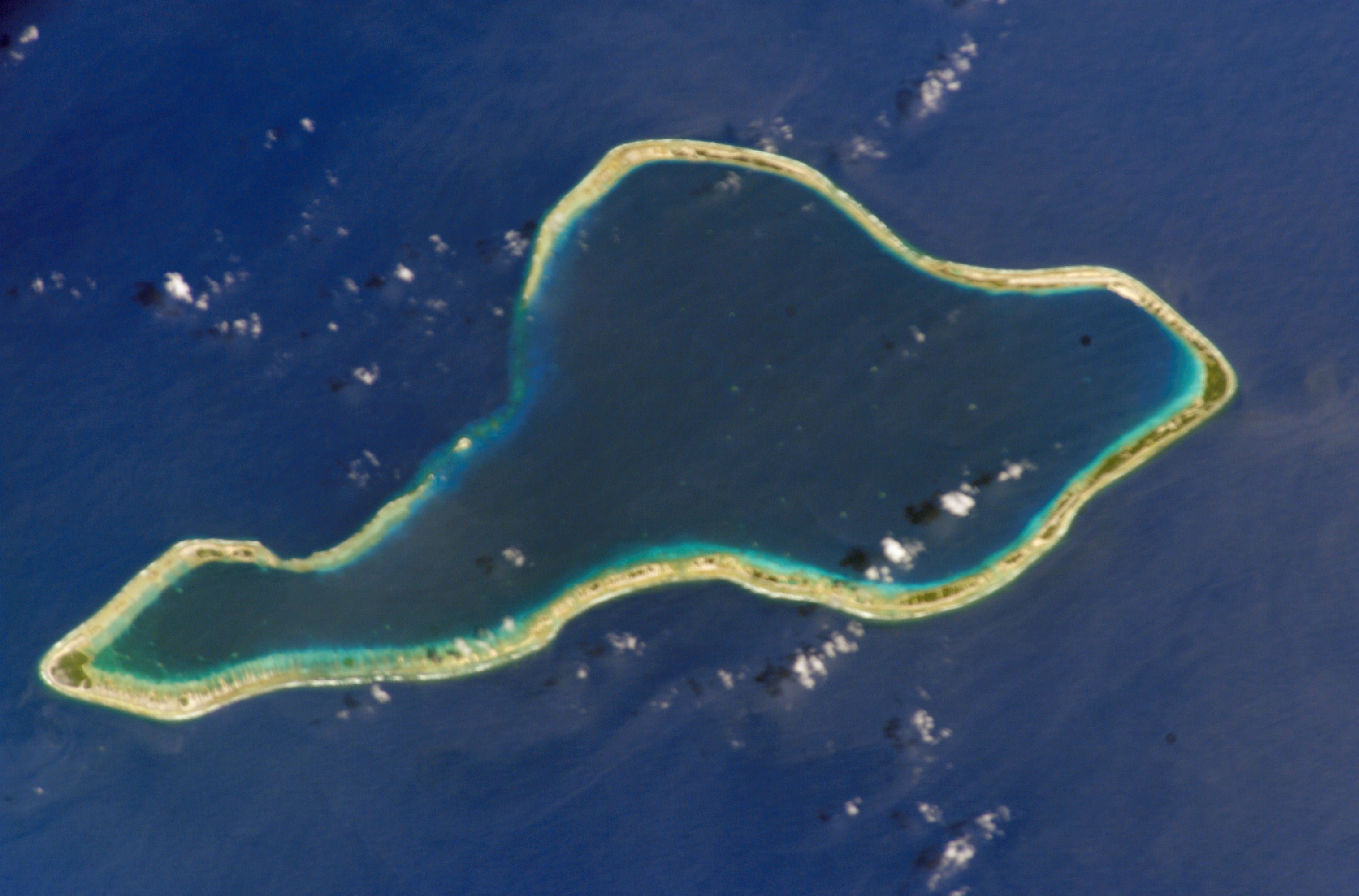
Deutsch: NASA-Astronautenbild des Mururoa-Atoll (Tuamotu-Archipel, Französisch-Polynesien) im Pazifischen Ozean
English: NASA astronaut image of Mururoa Atoll (Tuamotu Archipelago, French Polynesia) in the Pacific Ocean
Русский: Космический снимок НАСА атолла Муруроа (Туамоту, Французская Полинезия) в Тихом океане |
| Date | |
| Source | http://eol.jsc.nasa.gov/scripts/sseop/photo.pl?mission=ISS004&roll=E&frame=6730 |
| Author | NASA |
| Permission (Reusing this file) |
Conditions of Use of Astronaut Photographs |
This image or video was catalogued by Johnson Space Center of the United States National Aeronautics and Space Administration (NASA) under Photo ID: ISS004-E-6730. This tag does not indicate the copyright status of the attached work. A normal copyright tag is still required. See Commons:Licensing. Other languages:
|
Licensing
This file is in the public domain in the United States because it was created by the Image Science & Analysis Laboratory, of the NASA Johnson Space Center. NASA copyright policy states that "NASA material is not protected by copyright unless noted". (NASA media use guidelines or Conditions of Use of Astronaut Photographs).
Photo source: ISS004-E-6730.
|
File history
Click on a date/time to view the file as it appeared at that time.
| Date/Time | Thumbnail | Dimensions | User | Comment | |
|---|---|---|---|---|---|
| current | 13:16, 27 January 2011 | | 3,032 × 1,999 (1.01 MB) | Cropbot | upload cropped version, operated by User:Beao. Summary: cropped |
| 17:18, 9 December 2007 |  | 3,032 × 2,064 (1.02 MB) | Imjustmatthew~commonswiki | ||
| 16:59, 18 September 2005 |  | 639 × 435 (47 KB) | Los688 | Moruroa atoll.From http://eol.jsc.nasa.gov/scripts/sseop/photo.pl?mission=ISS004&roll=E&frame=6730 NASA ISS004 mision. Date: 2002.01.22 GMT Time: 18:44:13 Nadir Point Latitude: S 22.1, Longitude: W 140.5 Nadir to Photo Center Direction: East {{PD-USGov-N |
File usage
The following pages on the English Wikipedia use this file (pages on other projects are not listed):
Global file usage
The following other wikis use this file:
- Usage on ar.wikipedia.org
- Usage on ast.wikipedia.org
- Usage on bg.wikipedia.org
- Usage on br.wikipedia.org
- Usage on ca.wikipedia.org
- Usage on ceb.wikipedia.org
- Usage on cs.wikipedia.org
- Usage on de.wikipedia.org
- Usage on en.wiktionary.org
- Usage on eo.wikipedia.org
- Usage on es.wikipedia.org
- Usage on eu.wikipedia.org
- Usage on fa.wikipedia.org
- Usage on fi.wikipedia.org
- Usage on frr.wikipedia.org
- Usage on fr.wikipedia.org
- Usage on gl.wikipedia.org
- Usage on he.wikipedia.org
- Usage on hr.wikipedia.org
- Usage on hu.wikipedia.org
- Usage on id.wikipedia.org
- Usage on it.wikipedia.org
- Usage on ja.wikipedia.org
- Usage on ka.wikipedia.org
- Usage on ko.wikipedia.org
- Usage on lt.wikipedia.org
- Usage on mk.wikipedia.org
- Usage on ms.wikipedia.org
- Usage on nl.wikipedia.org
- Usage on no.wikipedia.org
- Usage on pl.wikipedia.org
- Usage on pt.wikipedia.org
- Usage on ro.wikipedia.org
View more global usage of this file.