
File:Monument Valley Sunset MC.jpg

Size of this preview: 800 × 406 pixels. Other resolutions: 320 × 162 pixels | 640 × 324 pixels | 1,024 × 519 pixels | 1,280 × 649 pixels | 4,000 × 2,028 pixels.
Original file (4,000 × 2,028 pixels, file size: 2.52 MB, MIME type: image/jpeg)
| This is a file from the Wikimedia Commons. Information from its description page there is shown below. Commons is a freely licensed media file repository. You can help. |
| Camera location | | View this and other nearby images on: OpenStreetMap |
|---|
| Description |
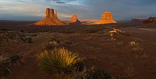
Deutsch: Das Monument Valley Navajo Tribal Park bei Sonnenuntergang. Von links nach rechts: Sentinel Mesa, The Mittens und Merrick Butte. Panorama zusammengesetzt aus 5 Hochformatbildern. Die Kamera wurde mit Hilfe eines Nodal Ninja [1] Nodalpunktadapters (der auf einem Stativ befestigt war) rotiert. Alle Fotos wurden mit denselben Belichtungseinstellungen im RAW Format aufgezeichnet und mit denselben Einstellungen in einem RAW Konverter entwickelt. Zum Zusammenfügen wurde PTGUI [2] verwendet.
English: The Monument Valley Navajo Tribal Park at sunset. From left to right: Sentinel Mesa, The Mittens, and Merrick Butte. Panorama stitched from 5 portrait format images. The camera was rotated using a Nodal Ninja [3] nodal point adapter which was mounted on a tripod. All photos were taken with the same exposure settings in RAW format and developed with exactly the same settings in a RAW converter. For stitching PTGUI [4] was used.
Français : Monument Valley au coucher du soleil. De gauche à droite on peut voir Sentinel Mesa (Le plateau de la sentinelle), The Mittens (Les moufles), et Merrick Butte. Panorama construit à partir de cinq clichés format portrait assemblées avec [PTGUI http://www.ptgui.com/]. |
| Date | Taken on 9 April 2008 |
| Source | Own work |
| Author | Christian Mehlführer, User:Chmehl |
| Permission (Reusing this file) |
I, the copyright holder of this work, hereby publish it under the following license: This file is licensed under the Creative Commons Attribution 2.5 Generic license.
|
This image has been assessed using the Quality image guidelines and is considered a Quality image.
|
File history
Click on a date/time to view the file as it appeared at that time.
| Date/Time | Thumbnail | Dimensions | User | Comment | |
|---|---|---|---|---|---|
| current | 20:53, 19 April 2008 | | 4,000 × 2,028 (2.52 MB) | Chmehl | {{Location|36|59|7.6|N|110|6|48.7|W|type:landmark}} {{Information |Description= {{de|Das Monument Valley Navajo Tribal Park bei Sonnenuntergang. Von links nach rechts: Sentinel Mesa, The Mittens und Merrick Butte. Panorama zusammen |
File usage
No pages on the English Wikipedia use this file (pages on other projects are not listed).
Global file usage
The following other wikis use this file:
- Usage on de.wikipedia.org
- Usage on fr.wikipedia.org
- Usage on id.wikipedia.org