File:Modio de Ponte Puñide (M.A.N. 1930-16-1) 01.jpg

This is a file from the Wikimedia Commons
From Wikipedia, the free encyclopedia

Original file(1,967 × 2,141 pixels, file size: 1.67 MB, MIME type: image/jpeg)

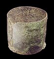
Called Modius of Ponte Puñide.   (Wikidata search (Cirrus search) Wikidata query (SPARQL)  Create new Wikidata item based on this file)
Title
Description
Date 4th century AD
date QS:P571,+350-00-00T00:00:00Z/7
Medium bronze
medium QS:P186,Q34095
Dimensions height: 22 cm (8.6 in); diameter: 26 cm (10.2 in)
dimensions QS:P2048,22U174728
dimensions QS:P2386,26U174728
institution QS:P195,Q1352282
Accession number
1930/16/1
Object history Place of discovery: Ponte Puñide (O Pino municipality, Province of A Coruña, Galicia, Spain). Date: 1913
Inscriptions
M O D I I L (E X), IVXTA SACRAM IVSSI [ON] EM DOMINORVM NOSTRORUM VALENTINIANI VALENTIS ET GRATIANI INVICTISSIMORVM PRINCIPVM, IVBENTE MARIO ARTEMIO V (IRO) C (LARISSÍMO) A [G] (ENTE) VIC (ARIAM) P (RAEFECTVRAM) (i), C V R (A N T I B V S) POTAMIO ET QUENTIANO PRINCIPALIBVS.

Inscription refers to the Lex Modii according to the legislation enacted by emperors Valentinian, Valens and Gratian, and sent to vicarius Marius Artemius (mentioned in the text), who regulated measurements and the taxes applied to them between years 367 and 375.
References

Museum's website – Web del museo – Site du musée

AE 1915, 75
• Epigraphische Datenbank Heidelberg HD029382
• Hispania Epigraphica 13931
Museum's website – Web del museo – Site du musée
Source/Photographer Luis García (Zaqarbal), 11 September 2009.
Permission
(Reusing this file)
I, the copyright holder of this work, hereby publish it under the following licenses:
GNU head Permission is granted to copy, distribute and/or modify this document under the terms of the GNU Free Documentation License, Version 1.2 or any later version published by the Free Software Foundation; with no Invariant Sections, no Front-Cover Texts, and no Back-Cover Texts. A copy of the license is included in the section entitled GNU Free Documentation License.
w:en:Creative Commons
attribution share alike
This file is licensed under the Creative Commons Attribution-Share Alike 3.0 Unported, 2.5 Generic, 2.0 Generic and 1.0 Generic license.
Attribution: Luis García
You are free:
  • to share – to copy, distribute and transmit the work
  • to remix – to adapt the work
Under the following conditions:
  • attribution – You must give appropriate credit, provide a link to the license, and indicate if changes were made. You may do so in any reasonable manner, but not in any way that suggests the licensor endorses you or your use.
  • share alike – If you remix, transform, or build upon the material, you must distribute your contributions under the same or compatible license as the original.
You may select the license of your choice.
Camera location40° 25′ 24.55″ N, 3° 41′ 20.61″ W Kartographer map based on OpenStreetMap.View this and other nearby images on: OpenStreetMapinfo

Captions

Add a one-line explanation of what this file represents

Items portrayed in this file

depicts

40°25'24.553"N, 3°41'20.605"W

0.078991 second

9.4 millimetre

image/jpeg

File history

Click on a date/time to view the file as it appeared at that time.

Date/TimeThumbnailDimensionsUserComment
current15:19, 3 October 2009Thumbnail for version as of 15:19, 3 October 20091,967 × 2,141 (1.67 MB)ZaqarbalTaken by Luis García (Zaqarbal) on September 11, 2009. Hereby published under GFDL and Cc-by-sa-3.0,2.5,2.0,1.0 licenses.
The following pages on the English Wikipedia use this file (pages on other projects are not listed):

Global file usage

The following other wikis use this file:

Metadata