
File:Model of the Igueriben Position 01.jpg

Size of this preview: 800 × 600 pixels. Other resolutions: 320 × 240 pixels | 640 × 480 pixels | 1,024 × 768 pixels | 1,280 × 960 pixels | 2,560 × 1,920 pixels | 4,000 × 3,000 pixels.
Original file (4,000 × 3,000 pixels, file size: 11.03 MB, MIME type: image/jpeg)
| This is a file from the Wikimedia Commons. Information from its description page there is shown below. Commons is a freely licensed media file repository. You can help. |
Summary
| Description |
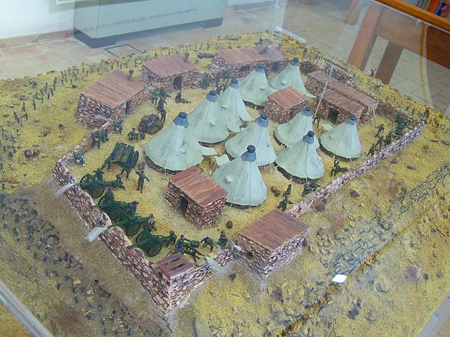
Español: Maqueta de la posición de Igueriben, con defensores y atacantes en acción, exhibida en la exposición La epopeya de Igueriben: Marruecos 1921 organizada por la asociación histórico-cultural Torrijos 1831 entre los días 1 y 20 julio de 2021 en el Centro de Interpretación Torrijos, en Málaga, España, con motivo del centenario del desastre de Annual. La maqueta muestra la posición de Igueriben con los soldados españoles abriendo fuego desde distintas ubicaciones defendiendo la posición de un ataque rifeño. Se observa la alambrada y el parapeto de piedra que rodea todo el perímetro, las tiendas de campaña y demás elementos de la posición. En el centro, junto a la tienda de mando situada a la altura del asta con la bandera de España, la figura del comandante Benítez, con gorra de oficial; en uno de los extremos, el camino de entrada a la posición cerrado con una barrera de estacas; en el otro extremo, un grupo de cañones de artillería comandados por el capitán Federico de la Paz Orduña, portando unos prismáticos. Autores: Juan Fernández Sastre y Esteban Alcántara Alcaide. |
| Date | |
| Source | Own work |
| Author | Daniel Capilla |
| Other versions |
|


| Camera location | | View this and other nearby images on: OpenStreetMap |
|---|
Licensing
Daniel Capilla, the copyright holder of this work, hereby publishes it under the following license:
This file is licensed under the Creative Commons Attribution-Share Alike 4.0 International license.
Attribution: Daniel Capilla
- You are free:
- to share – to copy, distribute and transmit the work
- to remix – to adapt the work
- Under the following conditions:
- attribution – You must give appropriate credit, provide a link to the license, and indicate if changes were made. You may do so in any reasonable manner, but not in any way that suggests the licensor endorses you or your use.
- share alike – If you remix, transform, or build upon the material, you must distribute your contributions under the same or compatible license as the original.
File history
Click on a date/time to view the file as it appeared at that time.
| Date/Time | Thumbnail | Dimensions | User | Comment | |
|---|---|---|---|---|---|
| current | 22:26, 8 July 2021 | | 4,000 × 3,000 (11.03 MB) | Dcapillae | Uploaded own work with UploadWizard |
File usage
The following pages on the English Wikipedia use this file (pages on other projects are not listed):
Global file usage
The following other wikis use this file:
- Usage on es.wikipedia.org
- Usage on www.wikidata.org