
File:Minnesota's earthquake epicenters.PNG
Size of this preview: 502 × 599 pixels. Other resolutions: 201 × 240 pixels | 599 × 715 pixels.
Original file (599 × 715 pixels, file size: 97 KB, MIME type: image/png)
| This is a file from the Wikimedia Commons. Information from its description page there is shown below. Commons is a freely licensed media file repository. You can help. |
Summary
| Description |
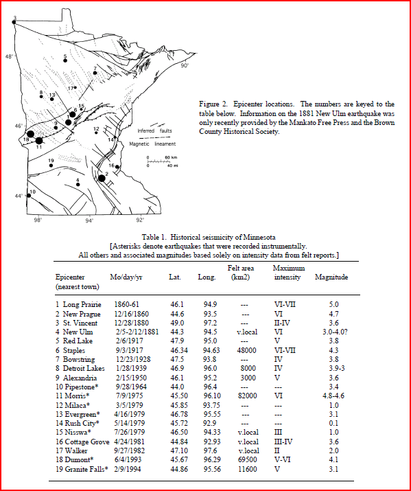
English: This map shows Minnesota's earthquake epicenters. |
| Date | |
| Source | Minnesota Geological Survey, University of Minnesota |
| Author | Regents of the University of Minnesota, V.W. Chandler |
At the bottom of the last page (page 4) it says "This document may be freely copied." Url=http://www.morris.umn.edu/earthquakes/glance.pdf
Licensing

|
The copyright holder of this work allows anyone to use it for any purpose including unrestricted redistribution, commercial use, and modification.
Usage notes:
|
File history
Click on a date/time to view the file as it appeared at that time.
| Date/Time | Thumbnail | Dimensions | User | Comment | |
|---|---|---|---|---|---|
| current | 02:22, 1 April 2010 | | 599 × 715 (97 KB) | Bettymnz4 | {{Information |Description={{en|1=This map shows Minnesota's earthquake epicenters.}} |Source=Minnesota Geological Survey, University of Minnesota |Author=Regents of the University of Minnesota, V.W. Chandler |Date=1994 |Permission= |other_versions= }} At |
File usage
The following pages on the English Wikipedia use this file (pages on other projects are not listed):