
File:Mining-Reporter-1904-What-The-Government.pdf

Size of this JPG preview of this PDF file: 463 × 599 pixels. Other resolutions: 185 × 240 pixels | 371 × 480 pixels | 593 × 768 pixels | 1,275 × 1,650 pixels.
Original file (1,275 × 1,650 pixels, file size: 363 KB, MIME type: application/pdf)
| This is a file from the Wikimedia Commons. Information from its description page there is shown below. Commons is a freely licensed media file repository. You can help. |
Summary
| Description |
English: Map B is substituted therefor as the official segregation sheet by which the government determine, what land is patented, what land is subject to patent and what land belongs to each respective patent; it is constructed on theoretical lines entirely, based upon original records. Map A is practice, map B is theory; map A is discarded by the land department, map B is adopted. Claims are thereby shifted about and officially anchored out of position. Land which is patented is thrown open to acquire- ment and may be patented to outsiders. Ground which is actually unpatented and open is construed to be patented to claims which occupy entirely different tracts....and as to every land section in all the mineral districts of Colorado and every other mining state. |
| Date | |
| Source | The Mining Reporter |
| Author | Mining Reporter |
Licensing
|
This work is in the public domain in its country of origin and other countries and areas where the copyright term is the author's life plus 70 years or fewer. This work is in the public domain in the United States because it was published (or registered with the U.S. Copyright Office) before January 1, 1929. | |
| This file has been identified as being free of known restrictions under copyright law, including all related and neighboring rights. | |
File history
Click on a date/time to view the file as it appeared at that time.
| Date/Time | Thumbnail | Dimensions | User | Comment | |
|---|---|---|---|---|---|
| current | 03:37, 9 January 2022 | 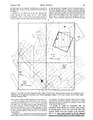 | 1,275 × 1,650 (363 KB) | Pazzo00 | Uploaded a work by Mining Reporter from The Mining Reporter with UploadWizard |
File usage
No pages on the English Wikipedia use this file (pages on other projects are not listed).