
File:Middlesex county 1875 - arlington - p101 500.jpg
Middlesex_county_1875_-_arlington_-_p101_500.jpg (500 × 410 pixels, file size: 31 KB, MIME type: image/jpeg)
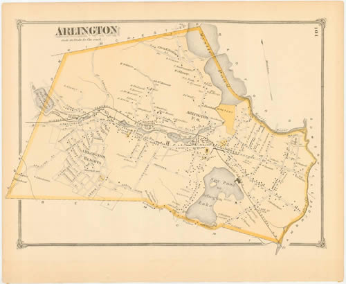
This map of Arlington is from an 1875 Beers Atlas of Middlesex County. The original map is about 15"x18" in size.
Source: Downloaded From
| This file is in the public domain in countries with a copyright term of life of the author plus 70 years or less. |  | |||
| ||||
 | This file is a candidate to be copied to Wikimedia Commons.
Any user may perform this transfer; refer to Wikipedia:Moving files to Commons for details. If this file has problems with attribution, copyright, or is otherwise ineligible for Commons, then remove this tag and DO NOT transfer it; repeat violators may be blocked from editing. Other Instructions
| ||
| |||
File history
Click on a date/time to view the file as it appeared at that time.
| Date/Time | Thumbnail | Dimensions | User | Comment | |
|---|---|---|---|---|---|
| current | 22:02, 25 May 2006 | | 500 × 410 (31 KB) | Bluemanboston (talk | contribs) | http://wardmaps.com/ward_maps/middlesex_co_1875/raw_scans/middlesex_county_1875_-_arlington_-_p101_500.jpg |
You cannot overwrite this file.