
File:Metula.svg

Size of this PNG preview of this SVG file: 766 × 600 pixels. Other resolutions: 307 × 240 pixels | 613 × 480 pixels | 981 × 768 pixels | 1,280 × 1,002 pixels | 2,560 × 2,004 pixels | 842 × 659 pixels.
Original file (SVG file, nominally 842 × 659 pixels, file size: 241 KB)
| This is a file from the Wikimedia Commons. Information from its description page there is shown below. Commons is a freely licensed media file repository. You can help. |
Summary
| Description |
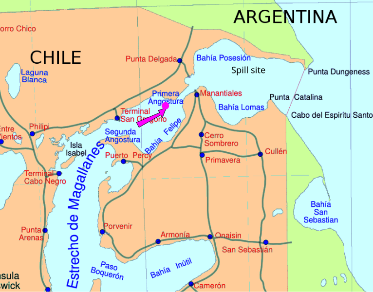
English: political map of southern Chile/Argentina: From Straits of Magellan to Cape Horn |
| Date | (UTC) |
| Source |
This file was derived from: South America southern tip pol.png: |
| Author |
|
| This is a retouched picture, which means that it has been digitally altered from its original version. Modifications: Metula oil spill. The original can be viewed here: South America southern tip pol.png:
|
Licensing
I, the copyright holder of this work, hereby publish it under the following licenses:
| This file is licensed under the Creative Commons Attribution-Share Alike 3.0 Unported license. | ||
| ||
| This licensing tag was added to this file as part of the GFDL licensing update. |

|
Permission is granted to copy, distribute and/or modify this document under the terms of the GNU Free Documentation License, Version 1.2 or any later version published by the Free Software Foundation; with no Invariant Sections, no Front-Cover Texts, and no Back-Cover Texts. A copy of the license is included in the section entitled GNU Free Documentation License. |
|
|
Permission is granted to copy, distribute and/or modify this document under the terms of the GNU Free Documentation License, Version 1.2 or any later version published by the Free Software Foundation; with no Invariant Sections, no Front-Cover Texts, and no Back-Cover Texts. A copy of the license is included in the section entitled GNU Free Documentation License. |
You may select the license of your choice.
The map has been created with the Generic Mapping Tools: https://www.generic-mapping-tools.org/ using one or more of these public-domain datasets for the relief:
|
|
|
Permission is granted to copy, distribute and/or modify this document under the terms of the GNU Free Documentation License, Version 1.2 or any later version published by the Free Software Foundation; with no Invariant Sections, no Front-Cover Texts, and no Back-Cover Texts. A copy of the license is included in the section entitled GNU Free Documentation License. |
Original upload log
This image is a derivative work of the following images:
- File:South_America_southern_tip_pol.png licensed with Cc-by-sa-3.0-migrated, GFDL, GFDL-GMT
- 2009-05-03T19:30:27Z Pitichinaccio 3894x2441 (654336 Bytes) different colour
- 2009-05-03T19:29:19Z Pitichinaccio 3894x2441 (654336 Bytes) {{Information |Description={{en|1=political map of southern Chile/Argentina: From Straits of Magellan to Cape Horn}} |Source=[[:File:Sur2.gif]] |Author=[[User:Createaccount]] |Date=2008 |Permission={{GFDL-GMT}}} |other_versio
Uploaded with derivativeFX
File history
Click on a date/time to view the file as it appeared at that time.
| Date/Time | Thumbnail | Dimensions | User | Comment | |
|---|---|---|---|---|---|
| current | 13:14, 12 April 2012 | | 842 × 659 (241 KB) | Keysanger | oil pill site was west of Primera Angostura, see http://www.gpo.gov/fdsys/pkg/CZIC-td195-p4-g86-1976/pdf/CZIC-td195-p4-g86-1976.pdf |
| 12:45, 12 April 2012 |  | 842 × 659 (241 KB) | Keysanger | == {{int:filedesc}} == {{Information |Description={{en|1=political map of southern Chile/Argentina: From Straits of Magellan to Cape Horn}} |Source={{Derived from|South_America_southern_tip_pol.png|display=50}} |Date=2012-04-12 12:44 (UTC) |Author=*[[:... |
File usage
The following pages on the English Wikipedia use this file (pages on other projects are not listed):
Global file usage
The following other wikis use this file:
- Usage on fr.wikipedia.org
- Usage on id.wikipedia.org