
File:Memorial to Tom Pryce, additional information - geograph.org.uk - 1614415.jpg
No higher resolution available.
Memorial_to_Tom_Pryce,_additional_information_-_geograph.org.uk_-_1614415.jpg (536 × 317 pixels, file size: 192 KB, MIME type: image/jpeg)
| This is a file from the Wikimedia Commons. Information from its description page there is shown below. Commons is a freely licensed media file repository. You can help. |
Summary
| Description |
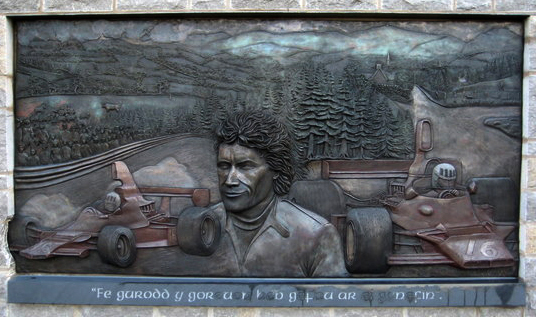
English: Memorial to Tom Pryce, additional information Tom was born at Rosset but moved to Ruthin with his parents and worked as an engineer for North Wales Agricultural Engineers in St Asaph (hence the tractor in the mural). Tom was driving for the F1 Shadow Team and making a name for himself as fast and skilled driver with a reputation for being unbeatable in the wet! The memorial was organised through a Trust chaired by local fellow Welshman and prominent motorsport chief David Richards of Prodrive, Benetton & BAR fame. The memorial is a fitting tribute to the only Welsh racing driver ever to win an F1 race and unveiled on what would have been his sixtieth birthday. |
| Date | |
| Source | From geograph.org.uk |
| Author | David M Jones |
| Attribution (required by the license) | David M Jones / Memorial to Tom Pryce, additional information / |
| Camera location | | View this and other nearby images on: OpenStreetMap |
|---|
_heading:67.00&language=en)
| Object location | | View this and other nearby images on: OpenStreetMap |
|---|
_heading:67.00&language=en)
Licensing

|
This image was taken from the Geograph project collection. See this photograph's page on the Geograph website for the photographer's contact details. The copyright on this image is owned by David M Jones and is licensed for reuse under the Creative Commons Attribution-ShareAlike 2.0 license.
|
This file is licensed under the Creative Commons Attribution-Share Alike 2.0 Generic license.
Attribution: David M Jones
- You are free:
- to share – to copy, distribute and transmit the work
- to remix – to adapt the work
- Under the following conditions:
- attribution – You must give appropriate credit, provide a link to the license, and indicate if changes were made. You may do so in any reasonable manner, but not in any way that suggests the licensor endorses you or your use.
- share alike – If you remix, transform, or build upon the material, you must distribute your contributions under the same or compatible license as the original.
File history
Click on a date/time to view the file as it appeared at that time.
| Date/Time | Thumbnail | Dimensions | User | Comment | |
|---|---|---|---|---|---|
| current | 22:29, 5 June 2014 | | 536 × 317 (192 KB) | Guinnog | crop, levels |
| 10:14, 4 March 2011 |  | 640 × 480 (82 KB) | GeographBot | == {{int:filedesc}} == {{Information |description={{en|1=Memorial to Tom Pryce, additional information Tom was born at Rosset but moved to Ruthin with his parents and worked as an engineer for North Wales Agricultural Engineers in St Asaph (hence the trac |
File usage
The following pages on the English Wikipedia use this file (pages on other projects are not listed):
Global file usage
The following other wikis use this file:
- Usage on cs.wikipedia.org
- Usage on de.wikipedia.org
- Usage on fr.wikipedia.org
- Usage on hu.wikipedia.org
- Usage on it.wikipedia.org
- Usage on ja.wikipedia.org
- Usage on simple.wikipedia.org
- Usage on www.wikidata.org