
File:Mazowieckie-administracja.png

Size of this preview: 587 × 599 pixels. Other resolutions: 235 × 240 pixels | 470 × 480 pixels | 752 × 768 pixels | 1,003 × 1,024 pixels | 1,652 × 1,687 pixels.
Original file (1,652 × 1,687 pixels, file size: 1.14 MB, MIME type: image/png)
| This is a file from the Wikimedia Commons. Information from its description page there is shown below. Commons is a freely licensed media file repository. You can help. |
Summary
| Description |
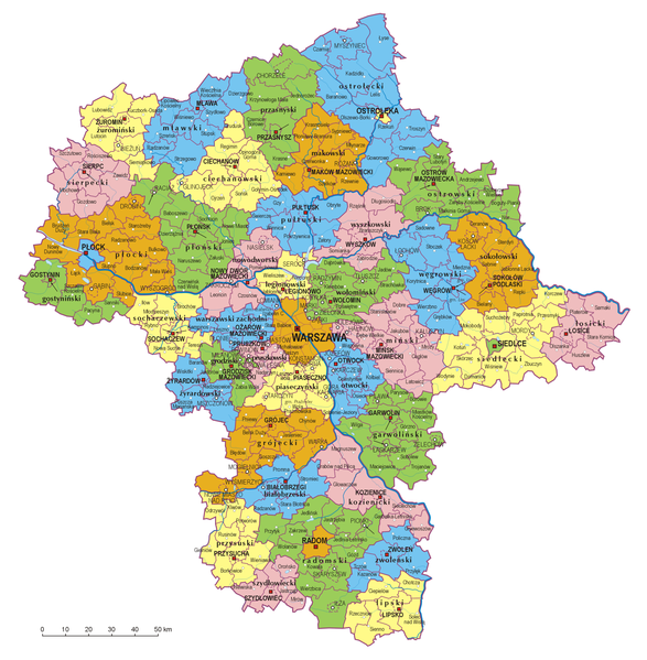
Polski: Mapa administracyjna województwa mazowieckiego, stan na 01.01.2007
 English: Administrative map of Mazowieckie Voivodship, as of January 1, 2007  |
||||||||
| Date | |||||||||
| Source | Self-made, based on Administrative Map of Poland 1:500.000 published by Head Office of Geodesy and Cartography with actualization | ||||||||
| Author | Aotearoa | ||||||||
| Permission (Reusing this file) |
I, the copyright holder of this work, hereby publish it under the following licenses:
This file is licensed under the Creative Commons Attribution 2.5 Generic license.
You may select the license of your choice. |

File history
Click on a date/time to view the file as it appeared at that time.
| Date/Time | Thumbnail | Dimensions | User | Comment | |
|---|---|---|---|---|---|
| current | 19:45, 10 May 2007 | | 1,652 × 1,687 (1.14 MB) | Aotearoa | |
| 14:38, 13 February 2007 |  | 1,652 × 1,687 (1.14 MB) | Aotearoa | {{Information |Description='''Polski''': Mapa administracyjna województwa mazowieckiego, stan na 01.01.2007<br> '''English''':Administrative map of Mazowieckie Voivodship, as of January 1, 2007 |Source=Self-made, based on Administrative Map of Poland 1: |
File usage
The following pages on the English Wikipedia use this file (pages on other projects are not listed):
Global file usage
The following other wikis use this file:
- Usage on ar.wikipedia.org
- Usage on azb.wikipedia.org
- Usage on az.wikipedia.org
- Usage on be.wikipedia.org
- Usage on bg.wikipedia.org
- Usage on ce.wikipedia.org
- Usage on da.wikipedia.org
- Usage on el.wikivoyage.org
- Usage on fa.wikipedia.org
- Usage on fr.wikipedia.org
- Usage on hsb.wikipedia.org
- Usage on hu.wikipedia.org
- Usage on it.wikipedia.org
- Usage on it.wikivoyage.org
- Usage on ja.wikipedia.org
- Usage on ko.wikipedia.org
- Usage on lt.wikipedia.org
- Usage on mk.wikipedia.org
- Usage on ms.wikipedia.org
- Usage on myv.wikipedia.org
- Usage on nl.wikipedia.org
- Usage on pl.wikipedia.org
- Usage on pl.wikivoyage.org
- Usage on ps.wikipedia.org
- Usage on pt.wikipedia.org
- Usage on simple.wikipedia.org
- Usage on sr.wikipedia.org
- Usage on tr.wikipedia.org
- Usage on ur.wikipedia.org
- Usage on vls.wikipedia.org
- Usage on yi.wikipedia.org
- Usage on zh.wikipedia.org