
File:Marine Atlantic ferry ports.png

Size of this preview: 428 × 599 pixels. Other resolutions: 171 × 240 pixels | 534 × 747 pixels.
Original file (534 × 747 pixels, file size: 22 KB, MIME type: image/png)
| This is a file from the Wikimedia Commons. Information from its description page there is shown below. Commons is a freely licensed media file repository. You can help. |
Summary
| Description |
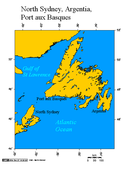
English: Argentia and Port aux Basques Newfoundland and North Sydney Nova Scotia
This map created using this online map creation tool. The following co-ordinates were used for the longitude and latitude:
This map uses the Lambert Azimuthal projection. See also |
| Date | 27 December 2004 (original upload date) |
| Source | Transferred from en.wikipedia to Commons. |
| Author | Geo Swan at English Wikipedia |
Licensing
| I, the copyright holder of this work, release this work into the public domain. This applies worldwide. In some countries this may not be legally possible; if so: I grant anyone the right to use this work for any purpose, without any conditions, unless such conditions are required by law. |

|
Permission is granted to copy, distribute and/or modify this document under the terms of the GNU Free Documentation License, Version 1.2 or any later version published by the Free Software Foundation; with no Invariant Sections, no Front-Cover Texts, and no Back-Cover Texts. A copy of the license is included in the section entitled GNU Free Documentation License. Subject to disclaimers. |
This file is licensed under the Creative Commons Attribution-Share Alike 3.0 Unported license.
- You are free:
- to share – to copy, distribute and transmit the work
- to remix – to adapt the work
- Under the following conditions:
- attribution – You must give appropriate credit, provide a link to the license, and indicate if changes were made. You may do so in any reasonable manner, but not in any way that suggests the licensor endorses you or your use.
- share alike – If you remix, transform, or build upon the material, you must distribute your contributions under the same or compatible license as the original.
Original upload log
The original description page was here. All following user names refer to en.wikipedia.
- 2005-08-03 03:20 Geo Swan 534×747×8 (22646 bytes) Reverted to earlier revision
- 2005-08-03 03:19 Geo Swan 534×747×8 (35691 bytes)
- 2004-12-27 15:00 Geo Swan 534×747×8 (22646 bytes) another version
- 2004-12-27 14:42 Geo Swan 514×601×8 (19753 bytes) better map of North Sydney Nova Scotia, Argentia and Port aux Basques Newfoundland
- 2004-12-27 03:35 Geo Swan 514×532×8 (14959 bytes) Argentia and Port aux Basques Newfoundland and North Sydney Nova Scotia
File history
Click on a date/time to view the file as it appeared at that time.
| Date/Time | Thumbnail | Dimensions | User | Comment | |
|---|---|---|---|---|---|
| current | 18:00, 25 November 2007 | | 534 × 747 (22 KB) | File Upload Bot (Magnus Manske) | {{BotMoveToCommons|en.wikipedia}} {{Information |Description={{en|Argentia and Port aux Basques Newfoundland and North Sydney Nova Scotia This map created using this [http://www.aquarius.geomar.de/omc/ online map creation tool]. The following co-ordinat |
File usage
The following pages on the English Wikipedia use this file (pages on other projects are not listed):
Global file usage
The following other wikis use this file:
- Usage on de.wikipedia.org
- Usage on fi.wikipedia.org
- Usage on id.wikipedia.org
- Usage on uk.wikipedia.org