
File:Mapbeer.jpg

Size of this preview: 799 × 382 pixels. Other resolutions: 320 × 153 pixels | 640 × 306 pixels | 1,024 × 490 pixels | 1,872 × 895 pixels.
Original file (1,872 × 895 pixels, file size: 673 KB, MIME type: image/jpeg)
| This is a file from the Wikimedia Commons. Information from its description page there is shown below. Commons is a freely licensed media file repository. You can help. |


Summary
| Description |
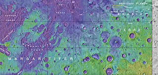
English: Map showing the location of Beer Crater and other, nearby features |
| Date | |
| Source | https://planetarynames.wr.usgs.gov/images/mc19_2014.pdf |
| Author | Jim Secosky modified NASA image. NASA/USGS |
Licensing
| This file is in the public domain in the United States because it was solely created by NASA. NASA copyright policy states that "NASA material is not protected by copyright unless noted". (See Template:PD-USGov, NASA copyright policy page or JPL Image Use Policy.) | ||
 |
Warnings:
|
File history
Click on a date/time to view the file as it appeared at that time.
| Date/Time | Thumbnail | Dimensions | User | Comment | |
|---|---|---|---|---|---|
| current | 17:41, 8 October 2017 | | 1,872 × 895 (673 KB) | Hemiauchenia | Cropped 2 % horizontally and < 1 % vertically using CropTool with lossless mode. removed tabs and windows taskbar |
| 17:24, 8 October 2017 |  | 1,915 × 898 (676 KB) | Hemiauchenia | Cropped < 1 % horizontally and 17 % vertically using CropTool with precise mode. removed chrome tabs and windows taskbar from image | |
| 22:00, 27 July 2017 |  | 1,920 × 1,080 (753 KB) | Jimmarsmars | {{Information |Description ={{en|1=Map showing the location of Beer Crater and other, nearby features}} |Source =https://planetarynames.wr.usgs.gov/images/mc19_2014.pdf |Author =Jim Secosky modified NASA image. NASA/USGS |Date... |
File usage
The following pages on the English Wikipedia use this file (pages on other projects are not listed):
Global file usage
The following other wikis use this file:
- Usage on cs.wikipedia.org
- Usage on es.wikipedia.org
- Usage on fa.wikipedia.org
- Usage on he.wikipedia.org
- Usage on zh.wikipedia.org