
File:Mapadefosas-mjusticia-es.jpg

Size of this preview: 628 × 600 pixels. Other resolutions: 251 × 240 pixels | 503 × 480 pixels | 838 × 800 pixels.
Original file (838 × 800 pixels, file size: 193 KB, MIME type: image/jpeg)
| This is a file from the Wikimedia Commons. Information from its description page there is shown below. Commons is a freely licensed media file repository. You can help. |
Summary
| Description |
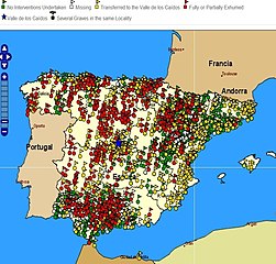
Español: Mapa de fosas de la Guerra Civil Española. Localización geográfica de las fosas o lugares de enterramiento en el territorio español de las que se dispone información, representadas con símbolos de diferentes colores según la actuación realizada sobre cada una de ellas. Verde: Fosa aún no intervenida. Blanco: Fosa aún no encontrada. Amarillo: Transferida al valle de los caídos. Rojo: parcial o totalmente exhumada.
http://mapadefosas.mjusticia.es/exovi_externo/CargarMapaFosas.htm
English: Spanish Civil War graves. Geographic location of the graves or burial places in Spanish territory on which information is available, represented with different coloured symbols based on the level of research performed. Green: No Interventions Undertaken White: Missing grave. Yellow: Transferred to the Valle de los Caídos. Red: Fully or Partially Exhumed. Blue star: Valle de los Caídos. |
| Date | |
| Source | Ministerio de Justicia de España, http://mapadefosas.mjusticia.es/ |
| Author | Ministerio de Justicia de España |
| Permission (Reusing this file) |
trabajo publico gubernamental, publicado en web del ministerio. Envío por mail mensaje de licencia |
| Camera location | | View this and other nearby images on: OpenStreetMap |
|---|
Licensing
This file is licensed under the Creative Commons Attribution 3.0 Unported license.
- You are free:
- to share – to copy, distribute and transmit the work
- to remix – to adapt the work
- Under the following conditions:
- attribution – You must give appropriate credit, provide a link to the license, and indicate if changes were made. You may do so in any reasonable manner, but not in any way that suggests the licensor endorses you or your use.

|
This image has been assessed under the valued image criteria and is considered the most valued image on Commons within the scope: Spanish Civil War casualties. You can see its nomination here. |
File history
Click on a date/time to view the file as it appeared at that time.
| Date/Time | Thumbnail | Dimensions | User | Comment | |
|---|---|---|---|---|---|
| current | 10:08, 4 March 2013 | | 838 × 800 (193 KB) | Gaianauta | corrected previous larger scale in E-W direction |
| 16:11, 13 July 2011 |  | 961 × 800 (225 KB) | Gaianauta | {{Information |Description ={{es|1=Mapa de fosas de la Guerra Civil Espàñola. Localización geográfica de las fosas o lugares de enterramiento en el territorio español de las que se dispone información, representadas con símbolos de diferentes co |
File usage
The following pages on the English Wikipedia use this file (pages on other projects are not listed):
Global file usage
The following other wikis use this file:
- Usage on ar.wikipedia.org
- Usage on ast.wikipedia.org
- Usage on bn.wikipedia.org
- Usage on ca.wikipedia.org
- Usage on es.wikipedia.org
- Usage on gl.wikipedia.org
- Usage on pl.wikipedia.org
- Usage on ur.wikipedia.org