
File:Mapa do Arquipélago de Fernando de Noronha.tif

Size of this JPG preview of this TIF file: 787 × 600 pixels. Other resolutions: 315 × 240 pixels | 630 × 480 pixels | 1,008 × 768 pixels | 1,280 × 976 pixels | 2,560 × 1,951 pixels | 9,761 × 7,440 pixels.
Original file (9,761 × 7,440 pixels, file size: 149.26 MB, MIME type: image/tiff)
| This is a file from the Wikimedia Commons. Information from its description page there is shown below. Commons is a freely licensed media file repository. You can help. |
Summary
| Title |
Mapa do Arquipélago de Fernando de Noronha |
||||||||||||||||||||||||||
| Description |
Português: Mapa do Arquipélago de Fernando de Noronha. Ministério da Indústria, Viação e Obras Públicas |
||||||||||||||||||||||||||
| Date | |||||||||||||||||||||||||||
| Source | Arquivo Nacional | ||||||||||||||||||||||||||
| Georeferencing | If inappropriate please set warp_status = skip to hide. | ||||||||||||||||||||||||||
| Archival data | |||||||||||||||||||||||||||
| Collection |
|
||||||||||||||||||||||||||
| Accession number |
BR_RJANRIO_4Q_0_MAP_0071 |
||||||||||||||||||||||||||

Licensing
This media is a faithful reproduction of public domain multimedia and it was the result of a GLAM partnership between the Arquivo Nacional and the Wikimedia Users Group in Brazil. The Arquivo Nacional (in English: The Brazilian National Archives) is an institution of the Brazilian Ministry of Justice and Public Security responsible for the management and preservation of documents pertaining to the federal public administration and located in the city of Rio de Janeiro.
Please attribute as: Public domain / Arquivo Nacional Collection Por favor, atribua como: Domínio público / Acervo Arquivo Nacional |
File history
Click on a date/time to view the file as it appeared at that time.
| Date/Time | Thumbnail | Dimensions | User | Comment | |
|---|---|---|---|---|---|
| current | 04:53, 30 March 2018 | 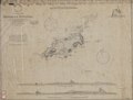 | 9,761 × 7,440 (149.26 MB) | Ederporto | pattypan 18.02 |
File usage
The following pages on the English Wikipedia use this file (pages on other projects are not listed):
Global file usage
The following other wikis use this file:
- Usage on de.wikipedia.org
- Usage on pt.wikipedia.org