
File:Mapa del Confín del Imperio Romano.gif

Original file (1,000 × 715 pixels, file size: 53 KB, MIME type: image/gif)
| This is a file from the Wikimedia Commons. Information from its description page there is shown below. Commons is a freely licensed media file repository. You can help. |
Summary
| Description |
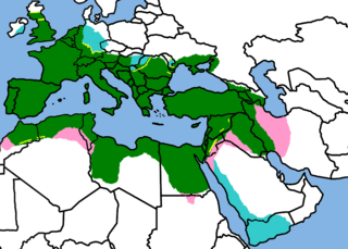
IMPORTANT IRELAND IS PAINTED BECAUSE THERE DID EXIST AN ATTEMPT TO INVADE IT, EVEN IF IT DIDN'T WORK. cyan means that the conquered land was never a Roman province because of
Map of the Roman Empire in it's greatest expansion, following the same proportional relations (that means, positions are exactly copied) of the Nuovo Atlante Storico De Agostini, by "Istituto Geografico De Agostini", [[ISBN 88-451-3698-5 Invalid ISBN]]. Novara 1995. The briefly occupated teritories (cyan and pink) are from the Corso di storia antica e medievale 1 (seconda edizione) by Augusto Camer and Renato Fabietti ISBN 88-08-24230-7 World shape is Image:A large blank world map with oceans marked in blue.gif
|
| Date | 3 October 2006 (original upload date) |
| Source | No machine-readable source provided. Own work assumed (based on copyright claims). |
| Author | No machine-readable author provided. Argentino assumed (based on copyright claims). |
Licensing

|
Permission is granted to copy, distribute and/or modify this document under the terms of the GNU Free Documentation License, Version 1.2 or any later version published by the Free Software Foundation; with no Invariant Sections, no Front-Cover Texts, and no Back-Cover Texts. A copy of the license is included in the section entitled GNU Free Documentation License. |
| This file is licensed under the Creative Commons Attribution-Share Alike 3.0 Unported license. | ||
| ||
| This licensing tag was added to this file as part of the GFDL licensing update. |
- You are free:
- to share – to copy, distribute and transmit the work
- to remix – to adapt the work
- Under the following conditions:
- attribution – You must give appropriate credit, provide a link to the license, and indicate if changes were made. You may do so in any reasonable manner, but not in any way that suggests the licensor endorses you or your use.
File history
Click on a date/time to view the file as it appeared at that time.
| Date/Time | Thumbnail | Dimensions | User | Comment | |
|---|---|---|---|---|---|
| current | 15:11, 28 July 2010 | | 1,000 × 715 (53 KB) | Argentino | Reverted to version as of 23:57, 5 July 2007 |
| 16:56, 29 January 2010 |  | 1,000 × 715 (51 KB) | Persia2099 | minor change | |
| 16:54, 29 January 2010 |  | 1,000 × 715 (51 KB) | Persia2099 | minor change | |
| 16:52, 29 January 2010 |  | 1,000 × 715 (65 KB) | Persia2099 | minor change | |
| 23:57, 5 July 2007 |  | 1,000 × 715 (53 KB) | Argentino | New version of the map, adding the berber tribes and Arabia Felix. | |
| 17:22, 3 October 2006 |  | 910 × 589 (31 KB) | Argentino | Map of the Roman Empire in it's greatest expansion, following the same proportional relations (that means, positions are exactly copied) of the ''Nouovo Atlanes Storico De Agostini'', by "Instituto Geografico De Agostini", ISBN 88-451-3698-5. Novara 1995. |
File usage
Global file usage
The following other wikis use this file:
- Usage on de.wikipedia.org
- Usage on fa.wikipedia.org
- Usage on sw.wikipedia.org