
File:Map of the Route of the Dorsland Trekkers.png

Size of this preview: 624 × 600 pixels. Other resolutions: 250 × 240 pixels | 499 × 480 pixels | 799 × 768 pixels | 1,065 × 1,024 pixels | 1,298 × 1,248 pixels.
Original file (1,298 × 1,248 pixels, file size: 265 KB, MIME type: image/png)
| This is a file from the Wikimedia Commons. Information from its description page there is shown below. Commons is a freely licensed media file repository. You can help. |
Summary
| Description |
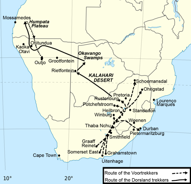
English: Map Of The Route Of The Dorsland Trekkers. Source: Map Of The Route Of The Thirstland Trekkers, which is taken from The Great Trek by Oliver Ransford (1968) |
| Date | (UTC) |
| Source |
This file was derived from: Africa location map.svg: |
| Author |
|
| Other versions |
 |
Licensing
I, the copyright holder of this work, hereby publish it under the following licenses:
This file is licensed under the Creative Commons Attribution-Share Alike 3.0 Unported license.
- You are free:
- to share – to copy, distribute and transmit the work
- to remix – to adapt the work
- Under the following conditions:
- attribution – You must give appropriate credit, provide a link to the license, and indicate if changes were made. You may do so in any reasonable manner, but not in any way that suggests the licensor endorses you or your use.
- share alike – If you remix, transform, or build upon the material, you must distribute your contributions under the same or compatible license as the original.

|
Permission is granted to copy, distribute and/or modify this document under the terms of the GNU Free Documentation License, Version 1.2 or any later version published by the Free Software Foundation; with no Invariant Sections, no Front-Cover Texts, and no Back-Cover Texts. A copy of the license is included in the section entitled GNU Free Documentation License. |
You may select the license of your choice.
Original upload log
This image is a derivative work of the following images:
- File:Africa_location_map.svg licensed with Cc-by-sa-3.0, GFDL
- 2012-10-02T12:40:15Z Palosirkka 1525x1440 (792744 Bytes) Reverted to version as of 19:13, 14 July 2011 Location maps must remain very accurate
- 2012-09-12T20:15:41Z Palosirkka 1525x1440 (537042 Bytes) Scrubbed with http://codedread.com/scour/
- 2011-07-14T19:13:55Z Sting 1525x1440 (792744 Bytes) Sudan/South Sudan 2011-07 border update
- 2010-07-02T20:12:15Z Sting 1525x1440 (586394 Bytes) == {{int:filedesc}} == {{Location|00|00|00|N|15|00|00|E|scale:30000000}} {{Information |Description={{en|Blank administrative map of political [[:en:Africa|Africa]], for geo-location purposes.}} {{fr|Carte administrative vier
Uploaded with derivativeFX
File history
Click on a date/time to view the file as it appeared at that time.
| Date/Time | Thumbnail | Dimensions | User | Comment | |
|---|---|---|---|---|---|
| current | 19:07, 30 January 2014 | | 1,298 × 1,248 (265 KB) | Underlying lk | improved quality |
| 03:43, 30 January 2014 |  | 649 × 624 (145 KB) | Underlying lk | m | |
| 03:25, 30 January 2014 |  | 649 × 624 (143 KB) | Underlying lk | == {{int:filedesc}} == {{Information |Description={{en|Map Of The Route Of The Dorsland Trekkers. Source: [http://www.ourcivilisation.com/smartboard/shop/ransford/map8.htm Map Of The Route Of The Thirstland Trekkers], which is taken from The Great Trek... |
File usage
The following pages on the English Wikipedia use this file (pages on other projects are not listed):
Global file usage
The following other wikis use this file:
- Usage on bn.wikipedia.org
- Usage on ca.wikipedia.org
- Usage on de.wikipedia.org
- Usage on fr.wikipedia.org
- Usage on mk.wikipedia.org
- Usage on pt.wikipedia.org