
File:Map of the Imperial Circles (1560)-en.svg

Size of this PNG preview of this SVG file: 613 × 600 pixels. Other resolutions: 245 × 240 pixels | 491 × 480 pixels | 785 × 768 pixels | 1,046 × 1,024 pixels | 2,093 × 2,048 pixels | 1,165 × 1,140 pixels.
Original file (SVG file, nominally 1,165 × 1,140 pixels, file size: 336 KB)
| This is a file from the Wikimedia Commons. Information from its description page there is shown below. Commons is a freely licensed media file repository. You can help. |
Summary
| Description |
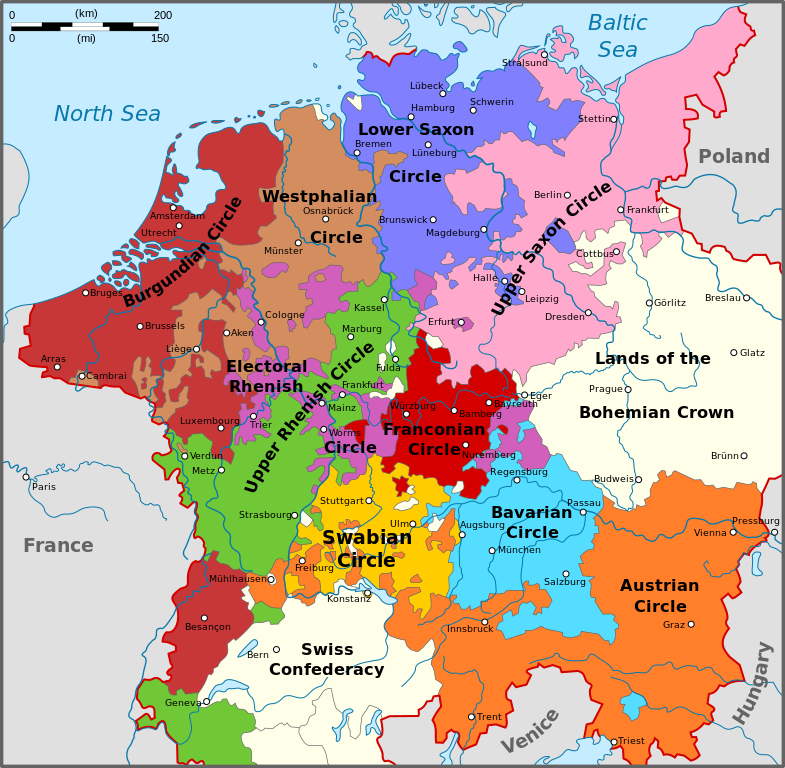
English: Map of the Imperial Circles after the Transaction of Augsburg (1548). English version.
Nederlands: Kaart van de Kreitsen na de Transactie van Augsburg (1548). Engelse versie.
Hrvatski: Karta okružja Svetog Rimskog Carstva nakon Augsburškog prijenosa iz 1548. Engleska inačica |
| Date | |
| Source | Own work |
| Author | Sir Iain |
| Other versions |
[] 1512
1560
|
-bg.png)
-de.png)
-en.png)
-fr.svg)
.png)
-de.svg)
-en.svg)
-es.svg)
-la.svg)
-nl.svg)
-en.svg)
Licensing
I, the copyright holder of this work, hereby publish it under the following licenses:
This file is licensed under the Creative Commons Attribution-Share Alike 3.0 Unported license.
- You are free:
- to share – to copy, distribute and transmit the work
- to remix – to adapt the work
- Under the following conditions:
- attribution – You must give appropriate credit, provide a link to the license, and indicate if changes were made. You may do so in any reasonable manner, but not in any way that suggests the licensor endorses you or your use.
- share alike – If you remix, transform, or build upon the material, you must distribute your contributions under the same or compatible license as the original.

|
Permission is granted to copy, distribute and/or modify this document under the terms of the GNU Free Documentation License, Version 1.2 or any later version published by the Free Software Foundation; with no Invariant Sections, no Front-Cover Texts, and no Back-Cover Texts. A copy of the license is included in the section entitled GNU Free Documentation License. |
You may select the license of your choice.
File history
Click on a date/time to view the file as it appeared at that time.
| Date/Time | Thumbnail | Dimensions | User | Comment | |
|---|---|---|---|---|---|
| current | 16:34, 14 August 2010 | | 1,165 × 1,140 (336 KB) | Sir Iain | The upper-Palatinate was actually part of the Electoral Rhenish Circle, contrary to almost all of the existing maps. |
| 10:42, 29 June 2010 |  | 1,165 × 1,140 (332 KB) | Sir Iain | Changed text on path to objects. Text on path wouldn't display correctly. | |
| 10:37, 29 June 2010 |  | 1,165 × 1,140 (279 KB) | Sir Iain | {{Information |Description={{en|1=Map of the Imperial Circles after the Transaction of Augsburg (1548). English version.}} {{nl|1=Kaart van de Kreitsen na de Transactie van Augsburg (1548). Engelse versie.}} |Source={{own}} |Author=[[User:Sir Iain|Sir Iai |
File usage
The following pages on the English Wikipedia use this file (pages on other projects are not listed):
Global file usage
The following other wikis use this file:
- Usage on az.wikipedia.org
- Usage on ca.wikipedia.org
- Usage on cs.wikipedia.org
- Usage on el.wikipedia.org
- Usage on et.wikipedia.org
- Usage on fi.wikipedia.org
- Usage on hr.wikipedia.org
- Usage on id.wikipedia.org
- Usage on ja.wikipedia.org
- Usage on ko.wikipedia.org
- Usage on lt.wikipedia.org
- Senoji konfederacija
- Cešyno kunigaikštystė
- Nysos kunigaikštystė
- Racibužo kunigaikštystė
- Opolės kunigaikštystė
- Bžego kunigaikštystė
- Legnicos kunigaikštystė
- Gloguvo kunigaikštystė
- Parmos hercogystė
- Milano hercogystė
- Čekijos karalystė
- Monferato marka
- Frankonijos imperinė apygarda
- Austrijos imperinė apygarda
- Šablonas:Šventosios Romos imperijos teritorijos
- Burgundijos imperinė apygarda
- Žemutinio Reino-Vestfalijos imperinė apygarda
- Italijos karalystė (viduramžiai)
- Moravijos markgrafystė
- Usage on lv.wikipedia.org
- Usage on no.wikipedia.org
- Usage on pt.wikipedia.org
- Usage on sh.wikipedia.org
- Usage on sr.wikipedia.org
- Usage on tr.wikipedia.org
- Usage on uk.wikipedia.org
- Usage on www.wikidata.org
- Usage on zh.wikipedia.org
-en.svg)