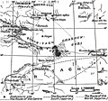
File:Map of eastern Xinjiang 1939 with prehistoric sites and the courses of the Silk Roads.jpg

Page contents not supported in other languages.
This is a file from the Wikimedia Commons
From Wikipedia, the free encyclopedia

Original file(831 × 777 pixels, file size: 297 KB, MIME type: image/jpeg)

Description
English: Map of eastern Xinjiang with prehistoric sites and the courses of the Silk Roads by Folke Bergman 1939.
Deutsch: Landkarte von Folke Bergman vom östlichen Xinjiang aus dem Jahr 1939 mit prähistorischen Fundstätten und den Routen der Seidenstraße. Bilderklärungen: . Prähistorische Fundstätte, ...... mittlere Route, — — — — vermutete südliche Route, - - - - - vermutete nördliche Route.
Date created: 1939 after the Sino-Swedish Expedition in China 1927-1933.
Source Map of eastern Xinjiang with prehistoric sites and the courses of the Silk Roads by Folke Bergman in his Book Archaeological Researches in Sinkiang. Especially the Lop-Nor Region. (Reports: Publication 7), Stockholm 1939, Page 25 Fig. 4. Copyright 2006: Sven Hedin foundation, Stockholm. [1]
Author Folke Bergman
Permission
(Reusing this file)

Permission cc-by-2.5 from the date 2006.08.23 by the keeper of the Sven Hedin Foundation Håkan Wahlquist, Box 27 140, SE-102 52 Stockholm, Sweden, Phone: +46-8-519 550 18, fax: +46-8-519 550 70, e-mail: hakan.wahlquist@etnografiska.se [2]

Svenska: Du måste ange upphovsmannen och/eller licensgivaren på det sätt de anger: Sven Hedin Foundation, Stockholm.
Deutsch: Namensnennung: Sie müssen den Namen des Autors/Rechtsinhabers Sven Hedin Foundation nennen: Sven Hedin Foundation, Stockholm.
w:en:Creative Commons
attribution
This file is licensed under the Creative Commons Attribution 2.5 Generic license.
You are free:
  • to share – to copy, distribute and transmit the work
  • to remix – to adapt the work
Under the following conditions:
  • attribution – You must give appropriate credit, provide a link to the license, and indicate if changes were made. You may do so in any reasonable manner, but not in any way that suggests the licensor endorses you or your use.

Captions

Add a one-line explanation of what this file represents

Items portrayed in this file

depicts

File history

Click on a date/time to view the file as it appeared at that time.

Date/TimeThumbnailDimensionsUserComment
current14:00, 18 September 2006Thumbnail for version as of 14:00, 18 September 2006831 × 777 (297 KB)Michael Gäbler{{Information| |Description= Map of eastern Xinjiang with prehistoric sites and the courses of the Silk Roads by Folke Bergman 1939. de: Landkarte von Folke Bergman vom östlichen Xinjiang aus dem Jahr 1939 mit prehistorischen Fundstätten und den Routen
The following pages on the English Wikipedia use this file (pages on other projects are not listed):

Global file usage

The following other wikis use this file:

Metadata