
File:Map of US 66.svg

Size of this PNG preview of this SVG file: 800 × 492 pixels. Other resolutions: 320 × 197 pixels | 640 × 394 pixels | 1,024 × 630 pixels | 1,280 × 788 pixels | 2,560 × 1,575 pixels | 1,500 × 923 pixels.
Original file (SVG file, nominally 1,500 × 923 pixels, file size: 2.02 MB)
| This is a file from the Wikimedia Commons. Information from its description page there is shown below. Commons is a freely licensed media file repository. You can help. |
Summary
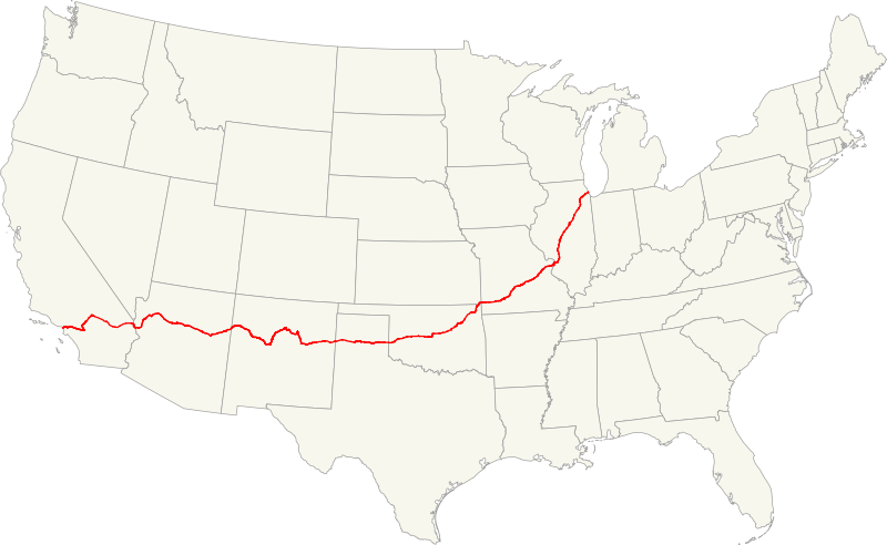
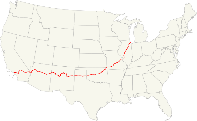
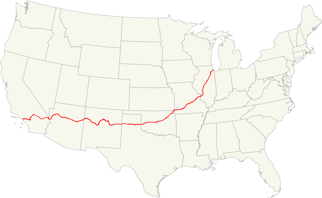
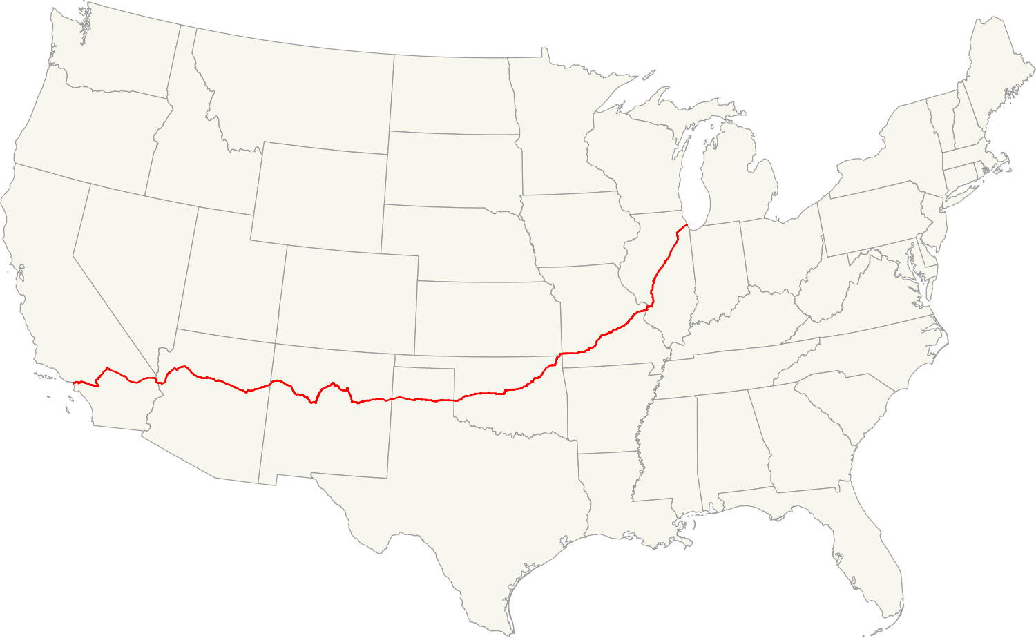
| Description | Map of former U.S. Route 66. |
| Date | |
| Source | USA map(GIS data), roads (GIS data), maps to help locate the route in GIS data |
| Author | Fredddie |
| Other versions |
Derivative works of this file: |
| SVG development |
Licensing
I, the copyright holder of this work, hereby publish it under the following licenses:
This file is licensed under the Creative Commons Attribution-Share Alike 3.0 Unported license.
- You are free:
- to share – to copy, distribute and transmit the work
- to remix – to adapt the work
- Under the following conditions:
- attribution – You must give appropriate credit, provide a link to the license, and indicate if changes were made. You may do so in any reasonable manner, but not in any way that suggests the licensor endorses you or your use.
- share alike – If you remix, transform, or build upon the material, you must distribute your contributions under the same or compatible license as the original.

|
Permission is granted to copy, distribute and/or modify this document under the terms of the GNU Free Documentation License, Version 1.2 or any later version published by the Free Software Foundation; with no Invariant Sections, no Front-Cover Texts, and no Back-Cover Texts. A copy of the license is included in the section entitled GNU Free Documentation License. |
You may select the license of your choice.
File history
Click on a date/time to view the file as it appeared at that time.
| Date/Time | Thumbnail | Dimensions | User | Comment | |
|---|---|---|---|---|---|
| current | 19:09, 30 December 2010 | | 1,500 × 923 (2.02 MB) | Fredddie | {{Information |Description=Map of former U.S. Route 66.{{QGIS}}{{Inkscape}} |Source=[http://www.census.gov/geo/cob/bdy/st/st00shp/st99_d00_shp.zip USA map](GIS data), [http://www.fhwa.dot.gov/planning/nhpn/2005/nhpn2005_08.zip roads] (GIS data), [http://w |
File usage
The following pages on the English Wikipedia use this file (pages on other projects are not listed):
- (Get Your Kicks on) Route 66
- Historic and Architectural Resources of Route 66 Through Illinois
- Route 66 Association
- Wikipedia:WikiProject U.S. Roads/Maps task force/Requests/Archive 7
- Portal:United States/Anniversaries/All
- Portal:United States/Anniversaries/June
- Portal:United States/Anniversaries/June/June 27
Global file usage
The following other wikis use this file:
- Usage on af.wikipedia.org
- Usage on ar.wikipedia.org
- Usage on bg.wikipedia.org
- Usage on ca.wikipedia.org
- Usage on cs.wikipedia.org
- Usage on eo.wikipedia.org
- Usage on es.wikipedia.org
- Usage on et.wikipedia.org
- Usage on eu.wikipedia.org
- Usage on fa.wikipedia.org
- Usage on fi.wikipedia.org
- Usage on hu.wikipedia.org
- Usage on it.wikipedia.org
- Usage on ja.wikipedia.org
- Usage on la.wikipedia.org
- Usage on lt.wikipedia.org
- Usage on nl.wikipedia.org
- Usage on no.wikipedia.org
- Usage on oc.wikipedia.org
- Usage on pt.wikipedia.org
- Usage on ro.wikipedia.org
- Usage on ru.wikipedia.org
- Usage on sq.wikipedia.org
- Usage on sv.wikipedia.org
- Usage on sv.wikivoyage.org
- Usage on tr.wikipedia.org
- Usage on uk.wikipedia.org
- Usage on ur.wikipedia.org
- Usage on www.wikidata.org
- Usage on zh.wikipedia.org