
File:Map of Paris by Claes Jansz. Visscher - Harold B. Lee Library.jpg

Size of this preview: 800 × 520 pixels. Other resolutions: 320 × 208 pixels | 640 × 416 pixels | 1,024 × 666 pixels | 1,280 × 832 pixels | 2,560 × 1,665 pixels | 20,207 × 13,139 pixels.
Original file (20,207 × 13,139 pixels, file size: 43.36 MB, MIME type: image/jpeg)
| This is a file from the Wikimedia Commons. Information from its description page there is shown below. Commons is a freely licensed media file repository. You can help. |
|
Summary
| Warning | The original file is very high-resolution. It might not load properly or could cause your browser to freeze when opened at full size. |
|---|
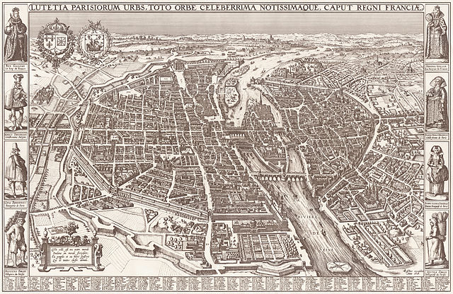
| Lutetia Parisorum urbs, toto orbe celeberrima notissimaque, caput regni Franciae.
( |
|||||||||||||||||||||||||||
|---|---|---|---|---|---|---|---|---|---|---|---|---|---|---|---|---|---|---|---|---|---|---|---|---|---|---|---|
| Author |
|
||||||||||||||||||||||||||
| Title |
Lutetia Parisorum urbs, toto orbe celeberrima notissimaque, caput regni Franciae. |
||||||||||||||||||||||||||
| Description |
Map of the city of Paris. Scale: ca. 1:2.000. |
||||||||||||||||||||||||||
| Date | 1618 | ||||||||||||||||||||||||||
| Dimensions | height: 55 cm (21.6 in); width: 85 cm (33.4 in) | ||||||||||||||||||||||||||
| Collection |
|
||||||||||||||||||||||||||
| References | Vrije Universiteit Amsterdam | ||||||||||||||||||||||||||
| Source/Photographer | Harold B. Lee Library Maps Collection | ||||||||||||||||||||||||||

Licensing
|
This work is in the public domain in its country of origin and other countries and areas where the copyright term is the author's life plus 100 years or fewer. | |
| This file has been identified as being free of known restrictions under copyright law, including all related and neighboring rights. | |

|
This image has been assessed under the valued image criteria and is considered the most valued image on Commons within the scope: Map of Paris by Claes Jansz. Visscher. You can see its nomination here. |
File history
Click on a date/time to view the file as it appeared at that time.
| Date/Time | Thumbnail | Dimensions | User | Comment | |
|---|---|---|---|---|---|
| current | 18:52, 21 November 2013 | | 20,207 × 13,139 (43.36 MB) | Paris 16 |
File usage
The following pages on the English Wikipedia use this file (pages on other projects are not listed):
Global file usage
The following other wikis use this file:
- Usage on ar.wikipedia.org
- Usage on az.wikipedia.org
- Usage on fr.wikipedia.org
- Usage on gl.wikipedia.org
- Usage on he.wikipedia.org
- Usage on it.wikipedia.org
- Usage on ja.wikipedia.org
- Usage on ko.wikipedia.org
- Usage on mg.wikipedia.org
- Usage on ms.wikipedia.org
- Usage on nl.wikipedia.org
- Usage on pl.wikipedia.org
- Usage on pnb.wikipedia.org
- Usage on ru.wikipedia.org
- Usage on uk.wikipedia.org
- Usage on ur.wikipedia.org
- Usage on vi.wikipedia.org
- Usage on www.wikidata.org